(function () {
var container = document.getElementById('popup2');
var content = document.getElementById('popup-content');
var closer = document.getElementById('popup-closer');
var overlay = new ol.Overlay({
element: container,
autoPan: true,
autoPanAnimation: {
duration: 250,
},
});
closer.onclick = function () {
overlay.setPosition(undefined);
closer.blur();
return false;
};
// PUNTI start ************************************************************************************
var style = [];
var vectorList_a = [];
var iconList = [];
style['750'] = {
'LineString': new ol.style.Style({
stroke: new ol.style.Stroke({
color: 'orange',
width: 3,
}),
}),
'MultiLineString': new ol.style.Style({
stroke: new ol.style.Stroke({
color: 'orange',
width: 3,
}),
}),
};
// GPX start
var vectorgpx = new ol.layer.Vector({
name: 'Percorso BVG',
description: ' ',
source: new ol.source.Vector({
url: ['/files/gpx/BVG_West_Track.gpx'],
radius: 0,
format: new ol.format.GPX()
}),
style: function (feature) {
return style['750'][feature.getGeometry().getType()];
},
});
vectorList_a.push(vectorgpx);
style['678'] = {
'Point': new ol.style.Style({
image: new ol.style.Circle({
fill: new ol.style.Fill({
color: 'rgba(255,255,0,0.6)',
}),
radius: 10,
stroke: new ol.style.Stroke({
color: '#ff0',
width: 1,
}),
}),
}),
'LineString': new ol.style.Style({
stroke: new ol.style.Stroke({
color: 'red',
width: 3,
}),
}),
'MultiLineString': new ol.style.Style({
stroke: new ol.style.Stroke({
color: 'red',
width: 3,
}),
}),
};
// GPX start
var t = new ol.Feature({
geometry: new ol.geom.Point(ol.proj.fromLonLat([10.610017, 45.657481])),
name: 'Gatto [Gat]',
description: '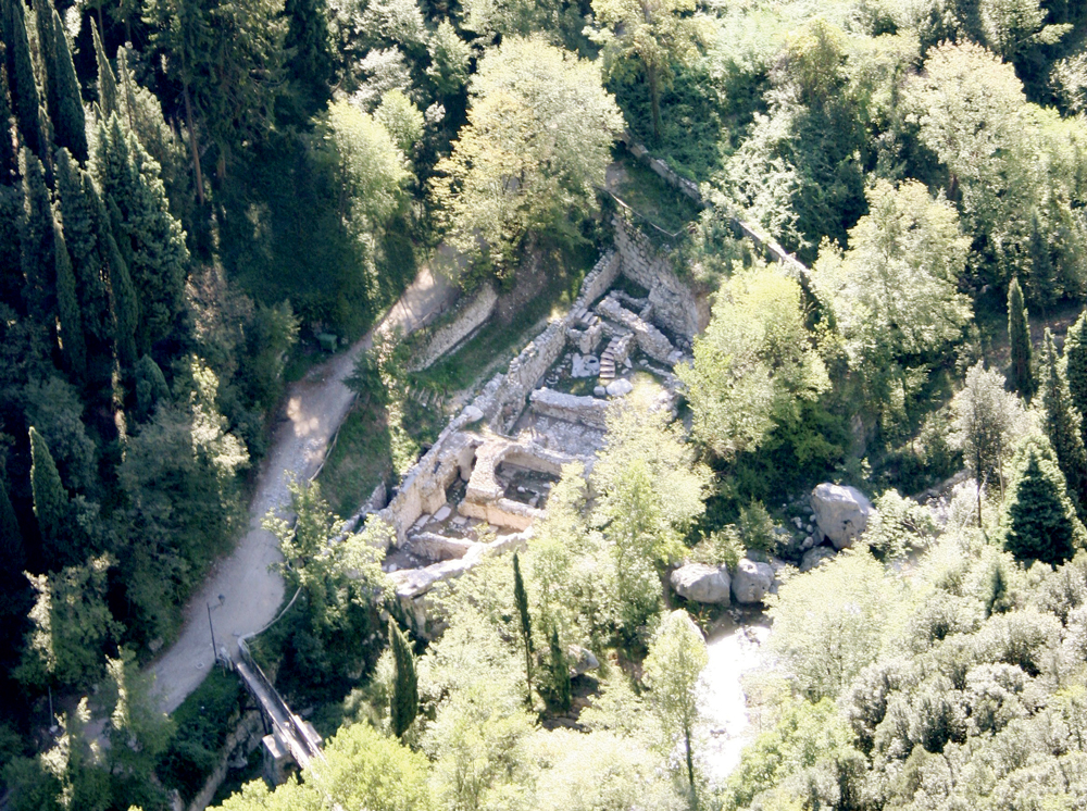
Al termine della strada, prima del ponte che attraversa il fiume, si trova la località oggi conosciuta con il nome di \"Gatto\" (Gàt), forse derivato dal soprannome di un proprietario.
Documentata già dal 1471, dal 2002 uno scavo archeologico ha permesso di riportare alla luce il piano seminterrato di un edificio articolato in origine su più piani e servito ad ovest dal canale della seriola. I resti murari più antichi risalgono al XV secolo.
Nell’Ottocento alcuni ambienti furono abbandonati e sulle loro rovine venne costruito un ponte in pietra già presente agli inizi del secolo, ricostruito in occasione della realizzazione della strada tra 1871 e 1878, e crollato a metà Novecento in seguito ad una piena. L’abbandono totale della cartiera avvenne alla fine dell’Ottocento.'
});
t.setStyle(
new ol.style.Style({
image: new ol.style.Circle({
fill: new ol.style.Fill({
color: 'red'
}),
radius: 8,
stroke: new ol.style.Stroke({
color: '#000000',
width: 1,
}),
}),
}),
);
iconList.push(t);
style['682'] = {
'Point': new ol.style.Style({
image: new ol.style.Circle({
fill: new ol.style.Fill({
color: 'rgba(255,255,0,0.6)',
}),
radius: 10,
stroke: new ol.style.Stroke({
color: '#ff0',
width: 1,
}),
}),
}),
'LineString': new ol.style.Style({
stroke: new ol.style.Stroke({
color: 'red',
width: 3,
}),
}),
'MultiLineString': new ol.style.Style({
stroke: new ol.style.Stroke({
color: 'red',
width: 3,
}),
}),
};
// GPX start
var t = new ol.Feature({
geometry: new ol.geom.Point(ol.proj.fromLonLat([10.60472805075, 45.650956671815])),
name: 'Maina di Mezzo',
description: '
Poco più a monte di Maina Inferiore si trovava il complesso produttivo di Maina di Mezzo, collegato un tempo a Maina Inferiore da un piccolo sentiero che costeggiava il fiume e parzialmente visibile dalla strada. Tra la fine dell’Ottocento e gli inizi del Novecento a Maina di Mezzo esisteva un assembramento notevole di edifici produttivi rimasti attivi per tutta la prima metà del Novecento. La vegetazione rigogliosa lascia intravedere soltanto alcune strutture, tra le quali spicca parte di una grande vasca in pietra di inizi Ottocento rimasta sospesa su uno dei pilastri portanti della fabbrica più vicina al fiume.
Nel 2007 parte di uno degli edifici di Maina di Mezzo è stato riportato alla luce grazie ad uno scavo archeologico, effettuato dall’Università di Padova.'
});
t.setStyle(
new ol.style.Style({
image: new ol.style.Circle({
fill: new ol.style.Fill({
color: 'red'
}),
radius: 8,
stroke: new ol.style.Stroke({
color: '#000000',
width: 1,
}),
}),
}),
);
iconList.push(t);
style['684'] = {
'Point': new ol.style.Style({
image: new ol.style.Circle({
fill: new ol.style.Fill({
color: 'rgba(255,255,0,0.6)',
}),
radius: 10,
stroke: new ol.style.Stroke({
color: '#ff0',
width: 1,
}),
}),
}),
'LineString': new ol.style.Style({
stroke: new ol.style.Stroke({
color: 'red',
width: 3,
}),
}),
'MultiLineString': new ol.style.Style({
stroke: new ol.style.Stroke({
color: 'red',
width: 3,
}),
}),
};
// GPX start
var t = new ol.Feature({
geometry: new ol.geom.Point(ol.proj.fromLonLat([10.60418403364, 45.649963002323])),
name: 'Maina Inferiore',
description: '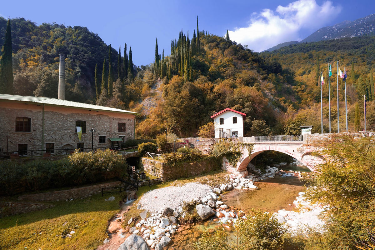
Il Centro di Eccellenza di Maina Inferiore è una cartiera completamente recuperata. Gli edifici produttivi di questa località risalgono al XV-XVI secolo. L\'edificio fu ampliato fino a fine Ottocento. La cartiera cessò la sua attività nel 1962.
Oggi è sede del Museo della Carta.
'
});
t.setStyle(
new ol.style.Style({
image: new ol.style.Circle({
fill: new ol.style.Fill({
color: 'red'
}),
radius: 8,
stroke: new ol.style.Stroke({
color: '#000000',
width: 1,
}),
}),
}),
);
iconList.push(t);
style['683'] = {
'Point': new ol.style.Style({
image: new ol.style.Circle({
fill: new ol.style.Fill({
color: 'rgba(255,255,0,0.6)',
}),
radius: 10,
stroke: new ol.style.Stroke({
color: '#ff0',
width: 1,
}),
}),
}),
'LineString': new ol.style.Style({
stroke: new ol.style.Stroke({
color: 'red',
width: 3,
}),
}),
'MultiLineString': new ol.style.Style({
stroke: new ol.style.Stroke({
color: 'red',
width: 3,
}),
}),
};
// GPX start
var t = new ol.Feature({
geometry: new ol.geom.Point(ol.proj.fromLonLat([10.605365, 45.652391])),
name: 'Maina Superiore',
description: '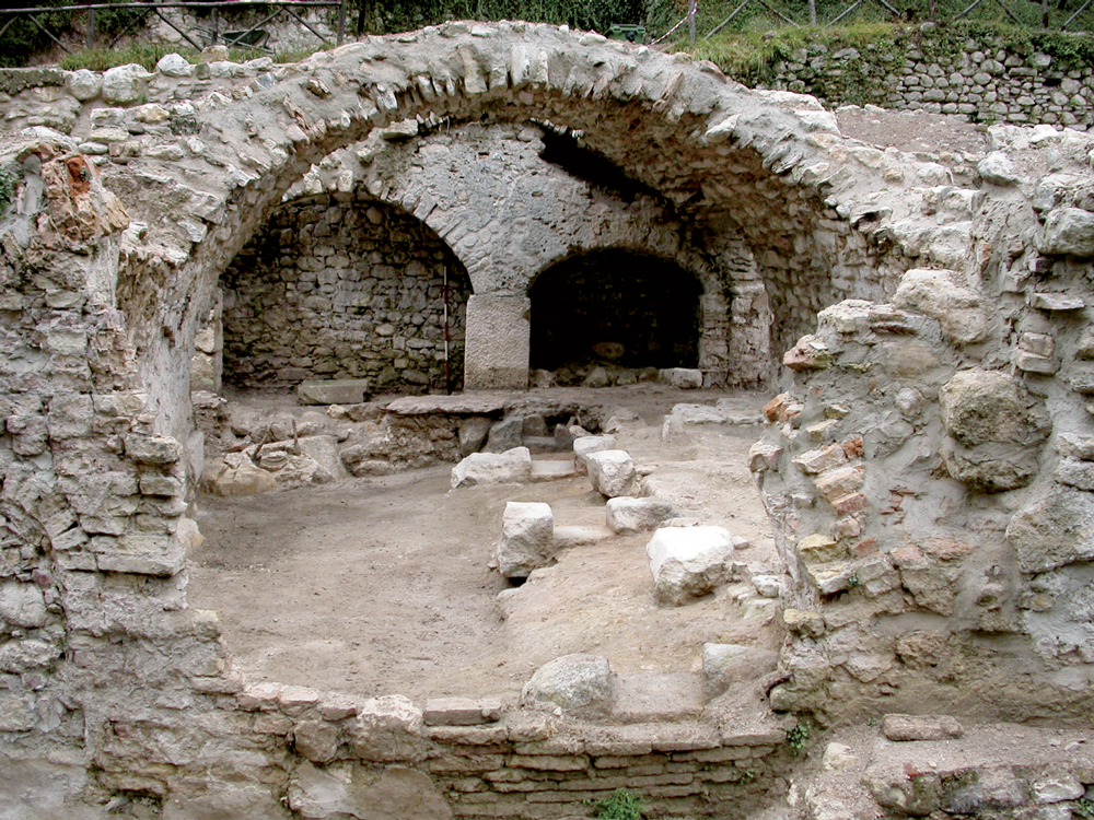
Qui, a fine Ottocento,si trovava il maggiore polo produttivo della zona e rappresentava il cuore di quella sorta di città lineare formata da fabbriche, magazzini, canali, abitazioni, orti e sentieri che riempiva lo stretto spazio del fondovalle.
A testimoniare la fisionomia del luogo restano solo alcune case, la villa in cui abitarono i Maffizzoli, che furono i maggiori protagonisti dello sviluppo industriale della valle, e i ruderi di edifici produttivi e di servizio a monte della casa padronale.
L’attività produttiva all’inizio del ‘900 venne trasferita dagli stessi Maffizzoli nella nuova cartiera a lago.
'
});
t.setStyle(
new ol.style.Style({
image: new ol.style.Circle({
fill: new ol.style.Fill({
color: 'red'
}),
radius: 8,
stroke: new ol.style.Stroke({
color: '#000000',
width: 1,
}),
}),
}),
);
iconList.push(t);
style['686'] = {
'Point': new ol.style.Style({
image: new ol.style.Circle({
fill: new ol.style.Fill({
color: 'rgba(255,255,0,0.6)',
}),
radius: 10,
stroke: new ol.style.Stroke({
color: '#ff0',
width: 1,
}),
}),
}),
'LineString': new ol.style.Style({
stroke: new ol.style.Stroke({
color: 'red',
width: 3,
}),
}),
'MultiLineString': new ol.style.Style({
stroke: new ol.style.Stroke({
color: 'red',
width: 3,
}),
}),
};
// GPX start
var t = new ol.Feature({
geometry: new ol.geom.Point(ol.proj.fromLonLat([10.606969, 45.653928])),
name: 'Vago [Vagh/Vach]',
description: '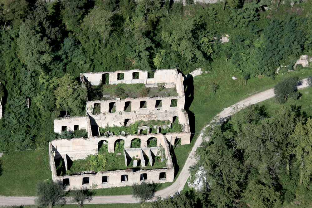
Il primo edificio risale al XIX secolo, è tipicamente industriale, al suo interno si conservano ancora grandi vasche piastrellate dei cilindri olandesi in cui avveniva la lavorazione degli stracci, mentre altre vasche, in cemento, ricordano il deposito delle sostanze chimiche impiegate per sbiancare la pasta destinata alla produzione della carta.
A monte un secondo edificio, nascosto dalla vegetazione, rappresenta il nucleo più antico del sito cartario di Vago.
'
});
t.setStyle(
new ol.style.Style({
image: new ol.style.Circle({
fill: new ol.style.Fill({
color: 'red'
}),
radius: 8,
stroke: new ol.style.Stroke({
color: '#000000',
width: 1,
}),
}),
}),
);
iconList.push(t);
style['687'] = {
'Point': new ol.style.Style({
image: new ol.style.Circle({
fill: new ol.style.Fill({
color: 'rgba(255,255,0,0.6)',
}),
radius: 10,
stroke: new ol.style.Stroke({
color: '#ff0',
width: 1,
}),
}),
}),
'LineString': new ol.style.Style({
stroke: new ol.style.Stroke({
color: 'red',
width: 3,
}),
}),
'MultiLineString': new ol.style.Style({
stroke: new ol.style.Stroke({
color: 'red',
width: 3,
}),
}),
};
// GPX start
var t = new ol.Feature({
geometry: new ol.geom.Point(ol.proj.fromLonLat([10.606623517149, 45.652427455979])),
name: 'Vancinelle',
description: 'Lungo la sponda sinistra del fiume, la strada conduceva al grande edificio di Vancinelle, detto anche Magazzino, di fronte al complesso di Maina Superiore, al quale era collegato da un ponticello. Fu costruito ex novo tra il 1852 e il 1898 e serviva come magazzino per il deposito delle merci. Il suo nome pare derivi dalla versione dialettale del cognome di una famiglia di proprietari di cartiere, gli Avanzini (Vansinèl).'
});
t.setStyle(
new ol.style.Style({
image: new ol.style.Circle({
fill: new ol.style.Fill({
color: 'red'
}),
radius: 8,
stroke: new ol.style.Stroke({
color: '#000000',
width: 1,
}),
}),
}),
);
iconList.push(t);
var iconLayer = new ol.layer.Vector({
source: new ol.source.Vector({
features: iconList,
}),
});
vectorList_a.push(iconLayer);
var vectorList_20 = [];
var iconList = [];
style['673'] = {
'Point': new ol.style.Style({
image: new ol.style.Circle({
fill: new ol.style.Fill({
color: 'rgba(255,255,0,0.6)',
}),
radius: 10,
stroke: new ol.style.Stroke({
color: '#ff0',
width: 1,
}),
}),
}),
'LineString': new ol.style.Style({
stroke: new ol.style.Stroke({
color: '#914f15',
width: 3,
}),
}),
'MultiLineString': new ol.style.Style({
stroke: new ol.style.Stroke({
color: '#914f15',
width: 3,
}),
}),
};
// GPX start
var t = new ol.Feature({
geometry: new ol.geom.Point(ol.proj.fromLonLat([10.590972039361224, 45.67376762402138])),
name: 'Bivacco “Due Aceri”',
description: 'Situato poco sotto la vetta del mponte Pizzocolo, vi si gode una splendida vista panoramica. Poco sopra c\'è una cappellina, sempre aperta (nella quale si celebra la S. Messa la terza domenica di giugno) e sulla vetta una croce e un’asta con tubicini attraverso i quali è possibile inquadrare e riconoscere alcune montagne.
Costruito sui ruderi di una costruzione militare risalente alla Prima guerra mondiale, il bivacco è formato da un solo locale con un camino, due tavoloni con relative panche e una cassetta di pronto soccorso. Una scala a pioli conduce ad un soppalco ove è possibile sostare la notte. '
});
t.setStyle(
new ol.style.Style({
image: new ol.style.Circle({
fill: new ol.style.Fill({
color: '#914f15'
}),
radius: 8,
stroke: new ol.style.Stroke({
color: '#000000',
width: 1,
}),
}),
}),
);
iconList.push(t);
var iconLayer = new ol.layer.Vector({
source: new ol.source.Vector({
features: iconList,
}),
});
vectorList_20.push(iconLayer);
var vectorList_35 = [];
var iconList = [];
style['757'] = {
'Point': new ol.style.Style({
image: new ol.style.Circle({
fill: new ol.style.Fill({
color: 'rgba(255,255,0,0.6)',
}),
radius: 10,
stroke: new ol.style.Stroke({
color: '#ff0',
width: 1,
}),
}),
}),
'LineString': new ol.style.Style({
stroke: new ol.style.Stroke({
color: '#609036',
width: 3,
}),
}),
'MultiLineString': new ol.style.Style({
stroke: new ol.style.Stroke({
color: '#609036',
width: 3,
}),
}),
};
// GPX start
var t = new ol.Feature({
geometry: new ol.geom.Point(ol.proj.fromLonLat([10.636869817742053, 45.66279674990764])),
name: 'Bogliaco Golf Resort',
description: '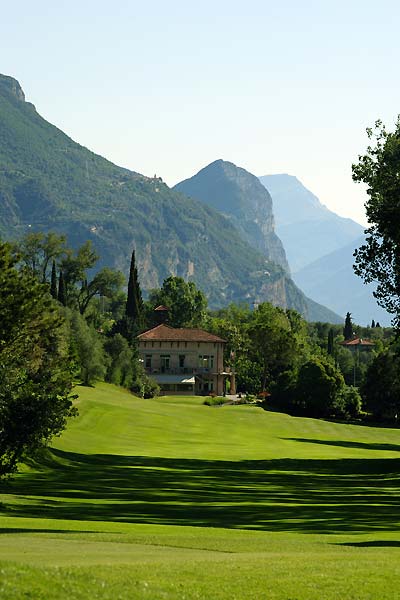
Il terzo campo da golf più antico d\'Italia, situato in una conca sopraelevata che consente una meravigliosa vista del Lago di Garda.
Aperto tutto l\'anno, grazie al clima mite che consente giornate temperate anche in inverno.
Un terreno di gioco circondato da limoni e ulivi secolari, specchi d\'acqua e piante tipiche della vegetazione mediterranea.
Percorso di 18 buche PAR70 con driving range, club house con ristorante e area lounge, apartments e un lodge con 10 camere. '
});
t.setStyle(
new ol.style.Style({
image: new ol.style.Circle({
fill: new ol.style.Fill({
color: '#609036'
}),
radius: 8,
stroke: new ol.style.Stroke({
color: '#000000',
width: 1,
}),
}),
}),
);
iconList.push(t);
var iconLayer = new ol.layer.Vector({
source: new ol.source.Vector({
features: iconList,
}),
});
vectorList_35.push(iconLayer);
var vectorList_19 = [];
var iconList = [];
style['669'] = {
'Point': new ol.style.Style({
image: new ol.style.Circle({
fill: new ol.style.Fill({
color: 'rgba(255,255,0,0.6)',
}),
radius: 10,
stroke: new ol.style.Stroke({
color: '#ff0',
width: 1,
}),
}),
}),
'LineString': new ol.style.Style({
stroke: new ol.style.Stroke({
color: '#159181',
width: 3,
}),
}),
'MultiLineString': new ol.style.Style({
stroke: new ol.style.Stroke({
color: '#159181',
width: 3,
}),
}),
};
// GPX start
var t = new ol.Feature({
geometry: new ol.geom.Point(ol.proj.fromLonLat([10.560180804632, 45.697801215542])),
name: 'Campèi de Sima',
description: '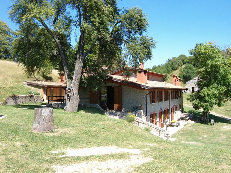
Il Rifugio Sezionale si trova a Campiglio di Cima (Campèi de Sìma), località del Comune di Toscolano Maderno, all’interno del Parco Naturalistico Alto Garda Bresciano, ad un\'altezza di 1.017 metri. Più che di un rifugio si tratta di un vero e proprio “borgo alpino”, composto da tre fabbricati e da una chiesetta intitolata alla Madonna della Neve. La ristrutturazione terminata nel 2000, frutto della sinergia tra ERSAF (proprietario dei fabbricati) e A.N.A., ha permesso nel giro di cinque anni di rendere fruibile il complesso delle malghe di Campiglio di Cima.'
});
t.setStyle(
new ol.style.Style({
image: new ol.style.Circle({
fill: new ol.style.Fill({
color: '#159181'
}),
radius: 8,
stroke: new ol.style.Stroke({
color: '#000000',
width: 1,
}),
}),
}),
);
iconList.push(t);
style['671'] = {
'Point': new ol.style.Style({
image: new ol.style.Circle({
fill: new ol.style.Fill({
color: 'rgba(255,255,0,0.6)',
}),
radius: 10,
stroke: new ol.style.Stroke({
color: '#ff0',
width: 1,
}),
}),
}),
'LineString': new ol.style.Style({
stroke: new ol.style.Stroke({
color: '#159181',
width: 3,
}),
}),
'MultiLineString': new ol.style.Style({
stroke: new ol.style.Stroke({
color: '#159181',
width: 3,
}),
}),
};
// GPX start
var t = new ol.Feature({
geometry: new ol.geom.Point(ol.proj.fromLonLat([10.556957635784, 45.678020597491])),
name: 'Rifugio \"Pirlo\" allo Spino',
description: '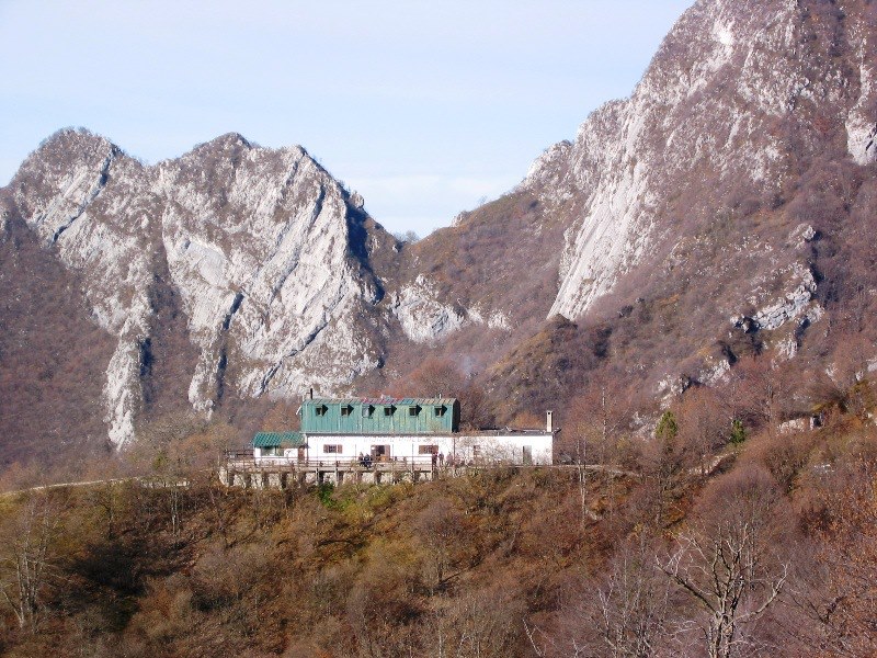
Rifugio di proprietà del Cai Salò, è aperto dalla primavera all\'autunno e nei fine settimana del restante periodo dell\'anno; è base di gite interessanti come il Pizzocolo (un\'ora e mezza di cammino) e il Monte Spino (meno di un\'ora). Ottimo punto di ristoro e di pernottamento e base di appoggio per coloro che vogliono cimentarsi sulle adiacenti ferrate attrezzate. Il Rifugio GIORGIO PIRLO allo SPINO 1165m sorge ai piedi dei monti Spino e Pizzocolo, punto nodale per coloro che effettuano giri in MTB oppure per escursionisti. Dotato di 2 grandi camerate per gruppi (40 posti letto) con servizi ed un ottimo ristorante. Possibilità di utilizzo della sala principale per incontri di gruppo. Facilmente raggiungibile da Toscolano Maderno e da Gaino. Rifugio a quota 1185 sul Monte Spino, eretto su un precedente casamento della Guardia di Finanza ed intitolato al tenente medico Giorgio Pirlo, caduto nella Seconda guerra mondiale.'
});
t.setStyle(
new ol.style.Style({
image: new ol.style.Circle({
fill: new ol.style.Fill({
color: '#159181'
}),
radius: 8,
stroke: new ol.style.Stroke({
color: '#000000',
width: 1,
}),
}),
}),
);
iconList.push(t);
var iconLayer = new ol.layer.Vector({
source: new ol.source.Vector({
features: iconList,
}),
});
vectorList_19.push(iconLayer);
var vectorList_24 = [];
var iconList = [];
style['722'] = {
'Point': new ol.style.Style({
image: new ol.style.Circle({
fill: new ol.style.Fill({
color: 'rgba(255,255,0,0.6)',
}),
radius: 10,
stroke: new ol.style.Stroke({
color: '#ff0',
width: 1,
}),
}),
}),
'LineString': new ol.style.Style({
stroke: new ol.style.Stroke({
color: '#be6acd',
width: 3,
}),
}),
'MultiLineString': new ol.style.Style({
stroke: new ol.style.Stroke({
color: '#be6acd',
width: 3,
}),
}),
};
// GPX start
var t = new ol.Feature({
geometry: new ol.geom.Point(ol.proj.fromLonLat([10.600096564629, 45.64535393265])),
name: 'Chiesa di San Martino',
description: '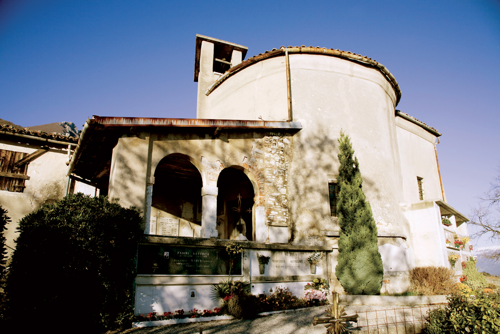
Nei pressi della frazione di Sanico, in località Prati di San Martino, su un cucuzzolo isolato vicino alla forra del torrente Toscolano, sorge la chiesetta di San Martino di Tours, usata come lazzaretto in caso di epidemie fin dall’inizio del Seicento. Il cimitero adiacente ospitava fino alla fine dell’Ottocento tutti i defunti di Maderno e delle sue frazioni. vi si addossa un piccolo edificio residenziale nel quale viveva un eremita. Il nucleo originario è l’edificio a pianta circolare che attualmente costituisce la navata della chiesa e che in origine doveva essere provvisto di una piccola abside a est e di un pronao a ovest'
});
t.setStyle(
new ol.style.Style({
image: new ol.style.Circle({
fill: new ol.style.Fill({
color: '#be6acd'
}),
radius: 8,
stroke: new ol.style.Stroke({
color: '#000000',
width: 1,
}),
}),
}),
);
iconList.push(t);
style['713'] = {
'Point': new ol.style.Style({
image: new ol.style.Circle({
fill: new ol.style.Fill({
color: 'rgba(255,255,0,0.6)',
}),
radius: 10,
stroke: new ol.style.Stroke({
color: '#ff0',
width: 1,
}),
}),
}),
'LineString': new ol.style.Style({
stroke: new ol.style.Stroke({
color: '#be6acd',
width: 3,
}),
}),
'MultiLineString': new ol.style.Style({
stroke: new ol.style.Stroke({
color: '#be6acd',
width: 3,
}),
}),
};
// GPX start
var t = new ol.Feature({
geometry: new ol.geom.Point(ol.proj.fromLonLat([10.614396139027365, 45.65462032356168])),
name: 'Chiesa di San Sebastiano',
description: '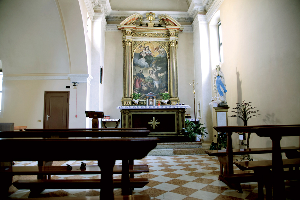
Piccola chiesa, nel centro della frazione di Gaino. Non si hanno notizie sull’epoca di costruzione. La devozione popolare invoca San sebastiano a protezione di malattie da contagio, e lo pone accanto a San Rocco e alla Madonna. Così è rappresentato nella tela cinque-seicentesca posta dietro l’altare.
'
});
t.setStyle(
new ol.style.Style({
image: new ol.style.Circle({
fill: new ol.style.Fill({
color: '#be6acd'
}),
radius: 8,
stroke: new ol.style.Stroke({
color: '#000000',
width: 1,
}),
}),
}),
);
iconList.push(t);
var iconLayer = new ol.layer.Vector({
source: new ol.source.Vector({
features: iconList,
}),
});
vectorList_24.push(iconLayer);
var vectorList_22 = [];
var iconList = [];
style['670'] = {
'Point': new ol.style.Style({
image: new ol.style.Circle({
fill: new ol.style.Fill({
color: 'rgba(255,255,0,0.6)',
}),
radius: 10,
stroke: new ol.style.Stroke({
color: '#ff0',
width: 1,
}),
}),
}),
'LineString': new ol.style.Style({
stroke: new ol.style.Stroke({
color: '#5a6360',
width: 3,
}),
}),
'MultiLineString': new ol.style.Style({
stroke: new ol.style.Stroke({
color: '#5a6360',
width: 3,
}),
}),
};
// GPX start
var t = new ol.Feature({
geometry: new ol.geom.Point(ol.proj.fromLonLat([10.584539139646, 45.671028637753])),
name: 'Malga Valle',
description: '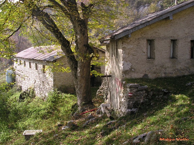
Piccola malga vicino alla sommità del monte Pizzocolo '
});
t.setStyle(
new ol.style.Style({
image: new ol.style.Circle({
fill: new ol.style.Fill({
color: '#5a6360'
}),
radius: 8,
stroke: new ol.style.Stroke({
color: '#000000',
width: 1,
}),
}),
}),
);
iconList.push(t);
var iconLayer = new ol.layer.Vector({
source: new ol.source.Vector({
features: iconList,
}),
});
vectorList_22.push(iconLayer);
var vectorList_26 = [];
var iconList = [];
style['707'] = {
'Point': new ol.style.Style({
image: new ol.style.Circle({
fill: new ol.style.Fill({
color: 'rgba(255,255,0,0.6)',
}),
radius: 10,
stroke: new ol.style.Stroke({
color: '#ff0',
width: 1,
}),
}),
}),
'LineString': new ol.style.Style({
stroke: new ol.style.Stroke({
color: '#3aa25f',
width: 3,
}),
}),
'MultiLineString': new ol.style.Style({
stroke: new ol.style.Stroke({
color: '#3aa25f',
width: 3,
}),
}),
};
// GPX start
var t = new ol.Feature({
geometry: new ol.geom.Point(ol.proj.fromLonLat([10.604170415888738, 45.64972537665636])),
name: 'Museo della Carta',
description: '
Il Polo Cartario di Maina Inferiore è un affascinante complesso produttivo trasformato in sede espositiva e museale. Al suo interno si ripercorrono le tappe della storia della produzione cartaria dal Medioevo al Novecento, attraverso un suggestivo percorso di visita che dal nucleo cinquecentesco della fabbrica, nel quale sono riprodotti macchinari e attrezzature caratteristici della produzione della carta dal XV al XVIII secolo, si snoda nelle ampie sale superiori, dedicate all’evoluzione della produzione nelle prime fasi della Rivoluzione Industriale. In esposizione anche reperti provenienti dagli scavi archeologici condotti nella Valle delle Cartiere, alcune filigrane prodotte tra XVI e XVIII secolo e una collezione di libri stampati dai Paganini, illustri stampatori con bottega a Toscolano e Venezia nella prima metà del Cinquecento.
Sempre dedicate ai Paganini e alle loro opere sono due installazioni interattive.
Oltre alle visite guidate e ai laboratori didattici legati alla storia della carta, il Centro organizza manifestazioni culturali, mostre ed eventi.
Info www.valledellecartiere.it
'
});
t.setStyle(
new ol.style.Style({
image: new ol.style.Circle({
fill: new ol.style.Fill({
color: '#3aa25f'
}),
radius: 8,
stroke: new ol.style.Stroke({
color: '#000000',
width: 1,
}),
}),
}),
);
iconList.push(t);
var iconLayer = new ol.layer.Vector({
source: new ol.source.Vector({
features: iconList,
}),
});
vectorList_26.push(iconLayer);
var vectorList_27 = [];
var iconList = [];
style['771'] = {
'Point': new ol.style.Style({
image: new ol.style.Circle({
fill: new ol.style.Fill({
color: 'rgba(255,255,0,0.6)',
}),
radius: 10,
stroke: new ol.style.Stroke({
color: '#ff0',
width: 1,
}),
}),
}),
'LineString': new ol.style.Style({
stroke: new ol.style.Stroke({
color: '#e7ceb0',
width: 3,
}),
}),
'MultiLineString': new ol.style.Style({
stroke: new ol.style.Stroke({
color: '#e7ceb0',
width: 3,
}),
}),
};
// GPX start
var t = new ol.Feature({
geometry: new ol.geom.Point(ol.proj.fromLonLat([10.605244, 45.652062])),
name: 'Palazzo Maffizzoli',
description: '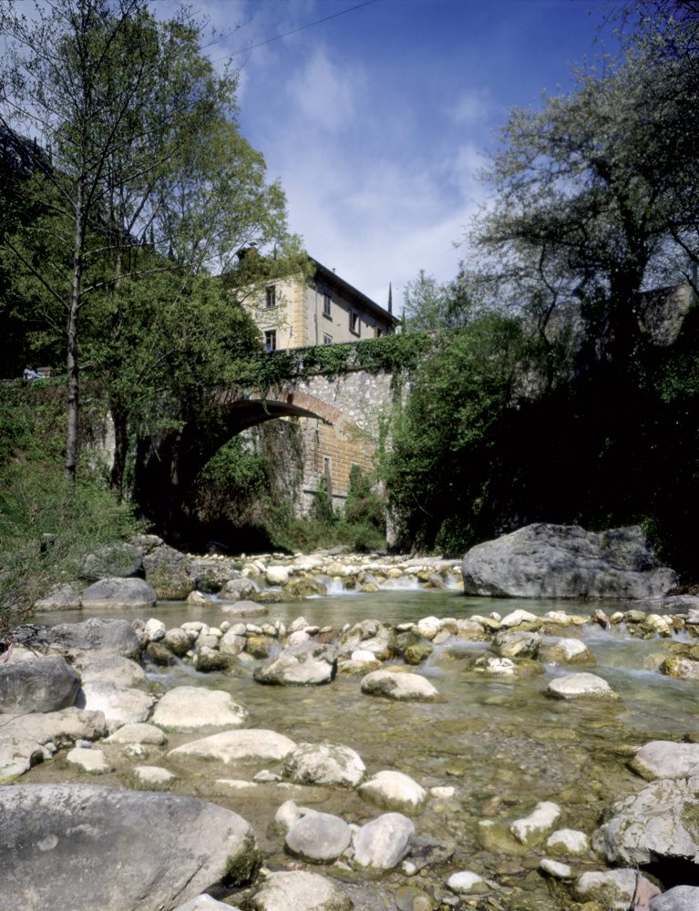
La villa, appartenuta alla famiglia di cartai Maffizzoli, fu costruita sul greto del fiume all’ingresso di Maina Superiore, che a fine ‘800 era il maggiore complesso produttivo della zona. '
});
t.setStyle(
new ol.style.Style({
image: new ol.style.Circle({
fill: new ol.style.Fill({
color: '#e7ceb0'
}),
radius: 8,
stroke: new ol.style.Stroke({
color: '#000000',
width: 1,
}),
}),
}),
);
iconList.push(t);
var iconLayer = new ol.layer.Vector({
source: new ol.source.Vector({
features: iconList,
}),
});
vectorList_27.push(iconLayer);
var vectorList_28 = [];
var iconList = [];
style['766'] = {
'Point': new ol.style.Style({
image: new ol.style.Circle({
fill: new ol.style.Fill({
color: 'rgba(255,255,0,0.6)',
}),
radius: 10,
stroke: new ol.style.Stroke({
color: '#ff0',
width: 1,
}),
}),
}),
'LineString': new ol.style.Style({
stroke: new ol.style.Stroke({
color: '#e9b3ff',
width: 3,
}),
}),
'MultiLineString': new ol.style.Style({
stroke: new ol.style.Stroke({
color: '#e9b3ff',
width: 3,
}),
}),
};
// GPX start
var t = new ol.Feature({
geometry: new ol.geom.Point(ol.proj.fromLonLat([10.605524804399648, 45.65258234901218])),
name: 'Riserva di pesca - Unione Pescatori Dilettanti del Garda',
description: 'Riserva di pesca in Valle delle Cartiere. Orari di apertura:
- dal 28/02/21 al 30/06/21 e dal 01/09/21 al 03/10/21 aperta dal venerdì alla domenica (6.30-11.30 / 13.00-19.00)
- dal 01/07/21 al 31/08/21 aperta tutti i giorni (6.30-11.30 / 14.00-19.00)
Permesso da pagare in loco
'
});
t.setStyle(
new ol.style.Style({
image: new ol.style.Circle({
fill: new ol.style.Fill({
color: '#e9b3ff'
}),
radius: 8,
stroke: new ol.style.Stroke({
color: '#000000',
width: 1,
}),
}),
}),
);
iconList.push(t);
var iconLayer = new ol.layer.Vector({
source: new ol.source.Vector({
features: iconList,
}),
});
vectorList_28.push(iconLayer);
var vectorList_13 = [];
var iconList = [];
style['715'] = {
'Point': new ol.style.Style({
image: new ol.style.Circle({
fill: new ol.style.Fill({
color: 'rgba(255,255,0,0.6)',
}),
radius: 10,
stroke: new ol.style.Stroke({
color: '#ff0',
width: 1,
}),
}),
}),
'LineString': new ol.style.Style({
stroke: new ol.style.Stroke({
color: 'violet',
width: 3,
}),
}),
'MultiLineString': new ol.style.Style({
stroke: new ol.style.Stroke({
color: 'violet',
width: 3,
}),
}),
};
// GPX start
var t = new ol.Feature({
geometry: new ol.geom.Point(ol.proj.fromLonLat([10.637406903483, 45.66953838257])),
name: 'Santuario della Madonna di Supina',
description: '
Il Santuario della Madonna di Supina fu edificato alla fine del XV secolo per devozione dal Comune di Toscolano. Dalla seconda metà del Cinquecento la comunità di Toscolano, per adempiere un voto, vi faceva celebrare messa il 25 di ogni mese. Nel 1581 Battista Sgraffignoli, tramite testamento, istituì un legato mediante il quale lasciava una cartiera di sua proprietà sita in contrada Lupo, nella Valle delle Cartiere, per la celebrazione di messe e per terminare la costruzione della chiesa e il suo ornamento. Seguendo tali disposizioni tra il 1583 e il 1590 venne eseguita la decorazione interna composta da una serie di tele con la storia della Vergine Maria inquadrate da cornici architettoniche affrescate. La statua della Madonna in trono posta nell’abside risale alla metà del XV secolo ed è collocata in un’ancona lignea seicentesca.'
});
t.setStyle(
new ol.style.Style({
image: new ol.style.Circle({
fill: new ol.style.Fill({
color: 'violet'
}),
radius: 8,
stroke: new ol.style.Stroke({
color: '#000000',
width: 1,
}),
}),
}),
);
iconList.push(t);
var iconLayer = new ol.layer.Vector({
source: new ol.source.Vector({
features: iconList,
}),
});
vectorList_13.push(iconLayer);
var vectorList_21 = [];
var iconList = [];
style['502'] = {
'Point': new ol.style.Style({
image: new ol.style.Circle({
fill: new ol.style.Fill({
color: 'rgba(255,255,0,0.6)',
}),
radius: 10,
stroke: new ol.style.Stroke({
color: '#ff0',
width: 1,
}),
}),
}),
'LineString': new ol.style.Style({
stroke: new ol.style.Stroke({
color: '#9ea752',
width: 3,
}),
}),
'MultiLineString': new ol.style.Style({
stroke: new ol.style.Stroke({
color: '#9ea752',
width: 3,
}),
}),
};
// GPX start
var t = new ol.Feature({
geometry: new ol.geom.Point(ol.proj.fromLonLat([10.570558909885, 45.657259340254])),
name: 'Sant’Urbano',
description: '
Tettoia in cemento con caminetto e punto bivacco.'
});
t.setStyle(
new ol.style.Style({
image: new ol.style.Circle({
fill: new ol.style.Fill({
color: '#9ea752'
}),
radius: 8,
stroke: new ol.style.Stroke({
color: '#000000',
width: 1,
}),
}),
}),
);
iconList.push(t);
var iconLayer = new ol.layer.Vector({
source: new ol.source.Vector({
features: iconList,
}),
});
vectorList_21.push(iconLayer);
var vectorList_32 = [];
var iconList = [];
style['764'] = {
'Point': new ol.style.Style({
image: new ol.style.Circle({
fill: new ol.style.Fill({
color: 'rgba(255,255,0,0.6)',
}),
radius: 10,
stroke: new ol.style.Stroke({
color: '#ff0',
width: 1,
}),
}),
}),
'LineString': new ol.style.Style({
stroke: new ol.style.Stroke({
color: '#51652b',
width: 3,
}),
}),
'MultiLineString': new ol.style.Style({
stroke: new ol.style.Stroke({
color: '#51652b',
width: 3,
}),
}),
};
// GPX start
var t = new ol.Feature({
geometry: new ol.geom.Point(ol.proj.fromLonLat([10.616492698691381, 45.65968024403243])),
name: 'Scuderia Castello',
description: 'Organizza passeggiate e trekking a cavallo, per principianti ed esperti, in collina e nel Parco dell’Alto Garda. '
});
t.setStyle(
new ol.style.Style({
image: new ol.style.Circle({
fill: new ol.style.Fill({
color: '#51652b'
}),
radius: 8,
stroke: new ol.style.Stroke({
color: '#000000',
width: 1,
}),
}),
}),
);
iconList.push(t);
var iconLayer = new ol.layer.Vector({
source: new ol.source.Vector({
features: iconList,
}),
});
vectorList_32.push(iconLayer);
// PUNTI end ************************************************************************************
var view = new ol.View({
center: ol.proj.transform([10.600677, 45.648558], 'EPSG:4326', 'EPSG:3857'),
//maxZoom: 18,
zoom: 14
})
var map = new ol.Map({
//controls: ol.control.defaults().extend([new ol.control.FullScreen()]),
target: 'map',
overlays: [overlay],
layers: [
// LAYOUT DELLA CARTINA
new ol.layer.Group({
title: 'Visualizza', // A layer must have a title to appear in the layerswitcher
layers: [
new ol.layer.Group({
title: 'Terreno', // A layer must have a title to appear in the layerswitcher
type: 'base', // Setting the layers type to 'base' results in it having a radio button and only one base layer being visibile at a time
combine: true, // Setting combine to true causes sub-layers to be hidden in the layerswitcher, only the parent is shown
visible: false,
layers: [
new ol.layer.Tile({
source: new ol.source.Stamen({
layer: 'terrain'
})
})
]
}),
new ol.layer.Tile({
title: 'Curve di livello',
type: 'base',
source: new ol.source.XYZ({
attributions: 'Tiles © ArcGIS',
url: 'https://server.arcgisonline.com/ArcGIS/rest/services/World_Topo_Map/MapServer/tile/{z}/{y}/{x}',
}),
}),
new ol.layer.Tile({
title: 'Satellite',
type: 'base',
source: new ol.source.XYZ({
attributions: 'Tiles © Esri — Source: Esri, i-cubed, USDA, USGS, AEX, GeoEye, Getmapping, Aerogrid, IGN, IGP, UPR-EGP, and the GIS User Community',
url: 'https://server.arcgisonline.com/ArcGIS/rest/services/World_Imagery/MapServer/tile/{z}/{y}/{x}.jpg',
maxZoom: 19,
}),
}),
new ol.layer.Tile({
title: 'Mappa', // A layer must have a title to appear in the layerswitcher
type: 'base', // Again set this layer as a base layer
visible: true,
source: new ol.source.OSM()
}),
]
}),
new ol.layer.Group({
title: 'Bassa via del Garda',
fold: 'open', // Adding a 'fold' property set to either 'open' or 'close' makes the group layer collapsible
layers: [
new ol.layer.Group({
title: '•
Altro',
layers: vectorList_a
}),
new ol.layer.Group({
title: '•
BIVACCO',
layers: vectorList_20
}),
new ol.layer.Group({
title: '•
GOLF',
layers: vectorList_35
}),
new ol.layer.Group({
title: '•
RIFUGIO',
layers: vectorList_19
}),
new ol.layer.Group({
title: '•
CHIESE',
layers: vectorList_24
}),
new ol.layer.Group({
title: '•
MALGA',
layers: vectorList_22
}),
new ol.layer.Group({
title: '•
MUSEI E PARCHI',
layers: vectorList_26
}),
new ol.layer.Group({
title: '•
VILLE E PALAZZI',
layers: vectorList_27
}),
new ol.layer.Group({
title: '•
PESCA',
layers: vectorList_28
}),
new ol.layer.Group({
title: '•
CULTO',
layers: vectorList_13
}),
new ol.layer.Group({
title: '•
TETTOIA',
layers: vectorList_21
}),
new ol.layer.Group({
title: '•
EQUITAZIONE',
layers: vectorList_32
}),
]
}),
],
view: view,
});
// GEOLOCALIZZAZIONE start ************************************************************************************
var geolocation = new ol.Geolocation({
// enableHighAccuracy must be set to true to have the heading value.
trackingOptions: {
enableHighAccuracy: true,
},
projection: view.getProjection(),
});
function el(id) {
return document.getElementById(id);
}
el('track').addEventListener('change', function () {
geolocation.setTracking(this.checked);
});
geolocation.on('change', function () {
el('accuracy').innerText = geolocation.getAccuracy() + ' [m]';
el('altitude').innerText = geolocation.getAltitude() + ' [m]';
el('altitudeAccuracy').innerText = geolocation.getAltitudeAccuracy() + ' [m]';
el('heading').innerText = geolocation.getHeading() + ' [rad]';
el('speed').innerText = geolocation.getSpeed() + ' [m/s]';
el('position').innerText = geolocation.getPosition();
});
// handle geolocation error.
geolocation.on('error', function (error) {
var info = document.getElementById('info-track');
info.innerHTML = error.message;
info.style.display = '';
});
var accuracyFeature = new ol.Feature();
geolocation.on('change:accuracyGeometry', function () {
accuracyFeature.setGeometry(geolocation.getAccuracyGeometry());
map.getView().animate({ center: geolocation.getPosition() }, { duration: 750 });
});
var positionFeature = new ol.Feature();
positionFeature.setStyle(
new ol.style.Style({
image: new ol.style.Circle({
radius: 6,
fill: new ol.style.Fill({
color: '#3399CC',
}),
stroke: new ol.style.Stroke({
color: '#fff',
width: 2,
}),
}),
})
);
// geolocation.on('change:position', function () {
geolocation.on('change', function () {
var coordinates = geolocation.getPosition();
positionFeature.setGeometry(coordinates ? new ol.geom.Point(coordinates) : null);
});
new ol.layer.Vector({
map: map,
source: new ol.source.Vector({
features: [accuracyFeature, positionFeature],
}),
});
// GEOLOCALIZZAZIONE end ************************************************************************************
// LINK To POINT start ************************************************************************************
// LINK To POINT end ************************************************************************************
// POPOUP start ************************************************************************************
var element = document.getElementById('popup');
var popup = new ol.Overlay({
element: element,
positioning: 'bottom-center',
stopEvent: false,
offset: [0, 0],
});
map.addOverlay(popup);
map.on('singleclick', function (evt) {
$(element).popover('dispose');
var feature = map.forEachFeatureAtPixel(evt.pixel, function (feature) {
return feature;
});
if (feature) {
var coordinate = evt.coordinate;
var hdms = ol.coordinate.toStringHDMS(ol.proj.toLonLat(coordinate));
content.innerHTML = '' + feature.get('name') + '
' + feature.get('description') + '
' + hdms + '';
overlay.setPosition(coordinate);
}
});
// POPOUP end ************************************************************************************
// Get out-of-the-map div element with the ID "layers" and renders layers to it.
// NOTE: If the layers are changed outside of the layer switcher then you
// will need to call ol.control.LayerSwitcher.renderPanel again to refesh
// the layer tree. Style the tree via CSS.
var sidebar = new ol.control.Sidebar({
element: 'sidebar',
position: 'left'
});
var toc = document.getElementById('layers');
ol.control.LayerSwitcher.renderPanel(map, toc, { reverse: true });
map.addControl(sidebar);
})();