(function () {
var container = document.getElementById('popup2');
var content = document.getElementById('popup-content');
var closer = document.getElementById('popup-closer');
var overlay = new ol.Overlay({
element: container,
autoPan: true,
autoPanAnimation: {
duration: 250,
},
});
closer.onclick = function () {
overlay.setPosition(undefined);
closer.blur();
return false;
};
// PUNTI start ************************************************************************************
var style = [];
var vectorList_38 = [];
var iconList = [];
style['660'] = {
'LineString': new ol.style.Style({
stroke: new ol.style.Stroke({
color: 'black',
width: 3,
}),
}),
'MultiLineString': new ol.style.Style({
stroke: new ol.style.Stroke({
color: 'black',
width: 3,
}),
}),
};
// GPX start
var vectorgpx = new ol.layer.Vector({
name: 'The Papermill Valley - Gaino',
description: 'Leave the main road SS45 bis near the bridge in Toscolano and go into the “Papermill Valley”. Leave your car at the car park and keep walking along the charming dirt road past the “Centro d’Eccellenza” in Maina Inferiore and as far as the bridge at Maina Superiore. Proceed along the valley as far as Gatto. The path goes up on the right along an old cobbled street. Keep to the left when you reach the paved street for about 200 m. until you get to a votive shrine (20 mins.).
Turn right to Via Giotto and after 50 m. turn right again into Via Donatello. Follow it on the right-hand side skirting the upper part of the historical centre and into the dirt lane of the “Morosini” and follow the ridge where you can enjoy an enchanting view of Gaino overlooking the lake.
Continue downhill among olive groves along a path to the fork on the right which will take you down to Maina (Papermill Valley). Turn left and follow the Toscolano river upstream on your right, as far as the Centro d’Eccellenza (a visit is suggested), and walk back to the car park.
TRAVEL: on foot
DIFFICULTY: easy
DURATION: 1:30 h
DISTANCE: 6 km
ALTITUDE: 220m
',
source: new ol.source.Vector({
url: ['/files/gpx/track_F.gpx'],
radius: 0,
format: new ol.format.GPX()
}),
style: function (feature) {
return style['660'][feature.getGeometry().getType()];
},
});
vectorList_38.push(vectorgpx);
var iconLayer = new ol.layer.Vector({
source: new ol.source.Vector({
features: iconList,
}),
});
vectorList_38.push(iconLayer);
var vectorList_a = [];
var iconList = [];
style['675'] = {
'Point': new ol.style.Style({
image: new ol.style.Circle({
fill: new ol.style.Fill({
color: 'rgba(255,255,0,0.6)',
}),
radius: 10,
stroke: new ol.style.Stroke({
color: '#ff0',
width: 1,
}),
}),
}),
'LineString': new ol.style.Style({
stroke: new ol.style.Stroke({
color: 'red',
width: 3,
}),
}),
'MultiLineString': new ol.style.Style({
stroke: new ol.style.Stroke({
color: 'red',
width: 3,
}),
}),
};
// GPX start
var t = new ol.Feature({
geometry: new ol.geom.Point(ol.proj.fromLonLat([10.608602239785, 45.656037132268])),
name: 'Caneto [Cané]',
description: '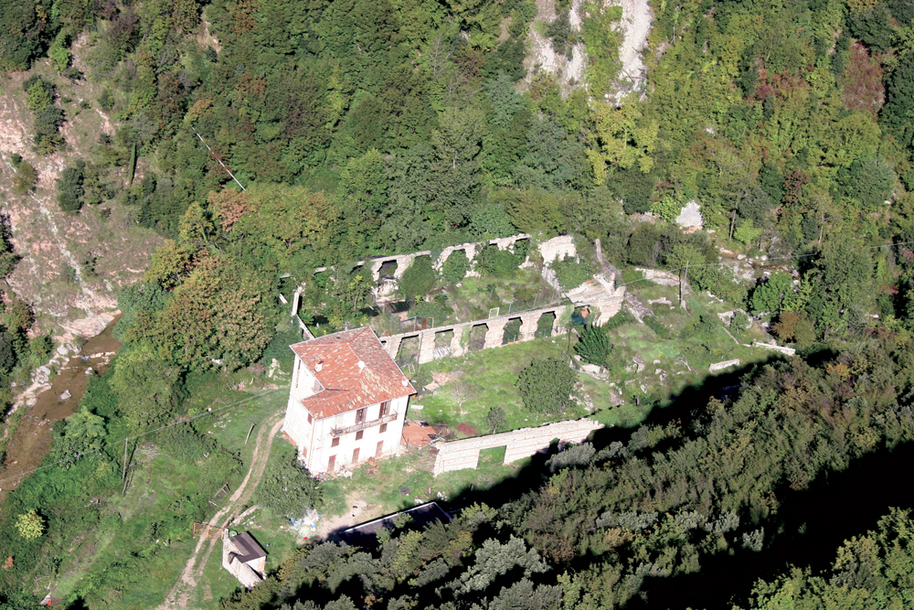
The first info about the existence of papermills in this valley dates back to the end of the XV Century. During the XVIII Century this locality, property of the Zuanelli family, was damaged by a flood. During the first half of the XIX Century the Simonellis restored some of the buildings and built a new paper mill. At the end of the century the Avanzini family, the last owner, added an oil mill.
'
});
t.setStyle(
new ol.style.Style({
image: new ol.style.Circle({
fill: new ol.style.Fill({
color: 'red'
}),
radius: 8,
stroke: new ol.style.Stroke({
color: '#000000',
width: 1,
}),
}),
}),
);
iconList.push(t);
style['676'] = {
'Point': new ol.style.Style({
image: new ol.style.Circle({
fill: new ol.style.Fill({
color: 'rgba(255,255,0,0.6)',
}),
radius: 10,
stroke: new ol.style.Stroke({
color: '#ff0',
width: 1,
}),
}),
}),
'LineString': new ol.style.Style({
stroke: new ol.style.Stroke({
color: 'red',
width: 3,
}),
}),
'MultiLineString': new ol.style.Style({
stroke: new ol.style.Stroke({
color: 'red',
width: 3,
}),
}),
};
// GPX start
var t = new ol.Feature({
geometry: new ol.geom.Point(ol.proj.fromLonLat([10.610224140363, 45.658316502998])),
name: 'Contrada [Cuntràda]',
description: '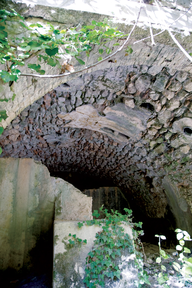
Now reduced to a narrow mule track, the last part of the path going up the valley is studded with vaults of rooms buried by vegetation, and with more recent structure in reinforced concrete goint towards the river. These ruins were parts of the productive settlement of Contrada, that once occupied the final part of the valley, between Luseti and Lume.
WARNING The papermill Valley is closed from Luseti to Covoli'
});
t.setStyle(
new ol.style.Style({
image: new ol.style.Circle({
fill: new ol.style.Fill({
color: 'red'
}),
radius: 8,
stroke: new ol.style.Stroke({
color: '#000000',
width: 1,
}),
}),
}),
);
iconList.push(t);
style['677'] = {
'Point': new ol.style.Style({
image: new ol.style.Circle({
fill: new ol.style.Fill({
color: 'rgba(255,255,0,0.6)',
}),
radius: 10,
stroke: new ol.style.Stroke({
color: '#ff0',
width: 1,
}),
}),
}),
'LineString': new ol.style.Style({
stroke: new ol.style.Stroke({
color: 'red',
width: 3,
}),
}),
'MultiLineString': new ol.style.Style({
stroke: new ol.style.Stroke({
color: 'red',
width: 3,
}),
}),
};
// GPX start
var t = new ol.Feature({
geometry: new ol.geom.Point(ol.proj.fromLonLat([10.609853367836, 45.662751596128])),
name: 'Covoli [Cùegn/Cùei]',
description: '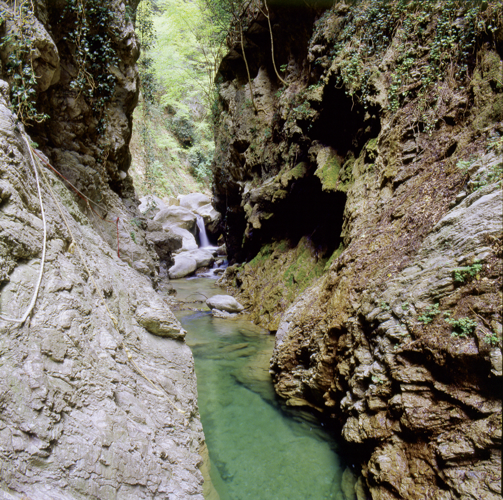
The first hydroelectric power station was built In Covoli, at the end of the valley, in 1899 and it lighted the Riviera. In this locality there there was also a papermill
WARNING This part of the Valley is temporarily closed
'
});
t.setStyle(
new ol.style.Style({
image: new ol.style.Circle({
fill: new ol.style.Fill({
color: 'red'
}),
radius: 8,
stroke: new ol.style.Stroke({
color: '#000000',
width: 1,
}),
}),
}),
);
iconList.push(t);
style['680'] = {
'Point': new ol.style.Style({
image: new ol.style.Circle({
fill: new ol.style.Fill({
color: 'rgba(255,255,0,0.6)',
}),
radius: 10,
stroke: new ol.style.Stroke({
color: '#ff0',
width: 1,
}),
}),
}),
'LineString': new ol.style.Style({
stroke: new ol.style.Stroke({
color: 'red',
width: 3,
}),
}),
'MultiLineString': new ol.style.Style({
stroke: new ol.style.Stroke({
color: 'red',
width: 3,
}),
}),
};
// GPX start
var t = new ol.Feature({
geometry: new ol.geom.Point(ol.proj.fromLonLat([10.610504154510712, 45.66082493865655])),
name: 'Covoli\'s gorge',
description: '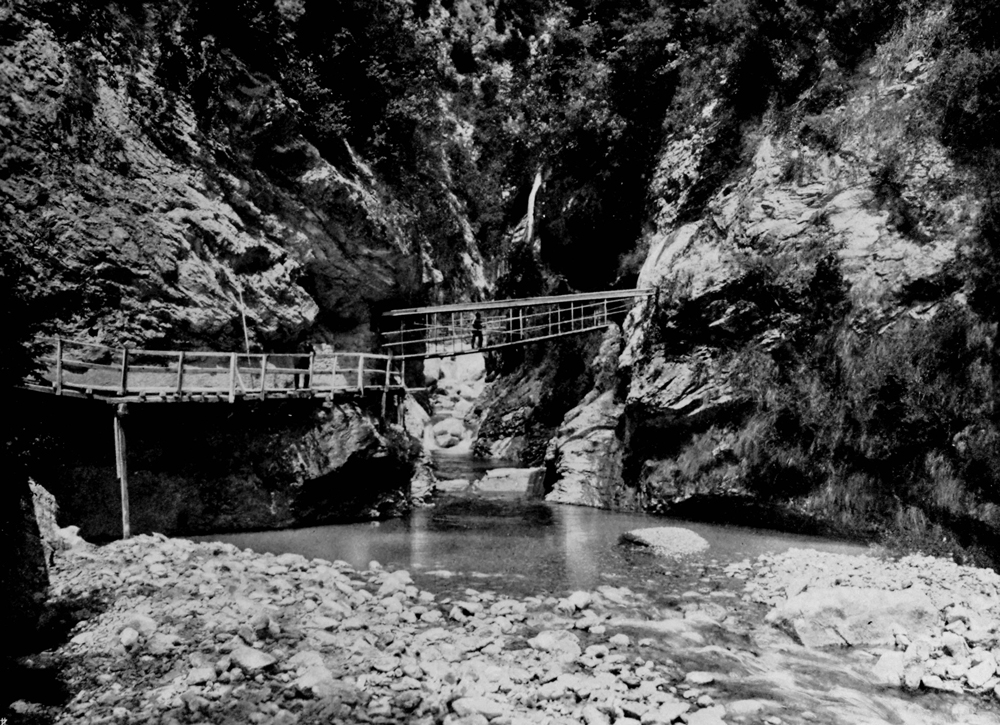
At the end of the valley the road branches off into two trails: the one on the right leads to a small tunnel carved into the rock (we invite you to walk through it only if equipped with a flashlight) that leads to the entrance of the gorge; the main one, on the left, leads to the Camerate Valley through a track, once made of wood, that crosses the gorge. The sight offered by the nature, with the carved rocks, the river and the vegetation is amazing.
WARNING This part of the Valley is temporarily closed
'
});
t.setStyle(
new ol.style.Style({
image: new ol.style.Circle({
fill: new ol.style.Fill({
color: 'red'
}),
radius: 8,
stroke: new ol.style.Stroke({
color: '#000000',
width: 1,
}),
}),
}),
);
iconList.push(t);
style['678'] = {
'Point': new ol.style.Style({
image: new ol.style.Circle({
fill: new ol.style.Fill({
color: 'rgba(255,255,0,0.6)',
}),
radius: 10,
stroke: new ol.style.Stroke({
color: '#ff0',
width: 1,
}),
}),
}),
'LineString': new ol.style.Style({
stroke: new ol.style.Stroke({
color: 'red',
width: 3,
}),
}),
'MultiLineString': new ol.style.Style({
stroke: new ol.style.Stroke({
color: 'red',
width: 3,
}),
}),
};
// GPX start
var t = new ol.Feature({
geometry: new ol.geom.Point(ol.proj.fromLonLat([10.610017, 45.657481])),
name: 'Gatto [Gat]',
description: '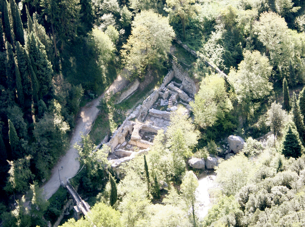
The locality at the end of the road, before the bridge that crosses the river, is today known as Gatto (Gàt), its name may derives from its owner epithet.
Since 2002 an archaeological excavation brought to light the semibasement of a building, origanally structured on several storeys and with a channel on its west side. The oldest ruins date back to the XV Century.
During the 1800s some of the spaces were abandoned and a stone bridge was built on the ruins. This bridge was then rebuilt with the construction of the new road between 1871 and 1878, and it finally fell down due to a flood. The paper mill was completely abandoned at the end of the XIX Century.'
});
t.setStyle(
new ol.style.Style({
image: new ol.style.Circle({
fill: new ol.style.Fill({
color: 'red'
}),
radius: 8,
stroke: new ol.style.Stroke({
color: '#000000',
width: 1,
}),
}),
}),
);
iconList.push(t);
style['679'] = {
'Point': new ol.style.Style({
image: new ol.style.Circle({
fill: new ol.style.Fill({
color: 'rgba(255,255,0,0.6)',
}),
radius: 10,
stroke: new ol.style.Stroke({
color: '#ff0',
width: 1,
}),
}),
}),
'LineString': new ol.style.Style({
stroke: new ol.style.Stroke({
color: 'red',
width: 3,
}),
}),
'MultiLineString': new ol.style.Style({
stroke: new ol.style.Stroke({
color: 'red',
width: 3,
}),
}),
};
// GPX start
var t = new ol.Feature({
geometry: new ol.geom.Point(ol.proj.fromLonLat([10.611468609507, 45.659592851797])),
name: 'Lume [Löm]',
description: '
According to a popular tradition the name Lume is due to the presence of a lamp (löm in dialect) that used to light up at night. However, considered its close position to the end of the valley, it may derives from the latin word limes that means border-limit. Lume is characterized by the presence of an olive grow on embankments, typical of the Riviera.
WARNING This part of the Valley is temporarily closed
'
});
t.setStyle(
new ol.style.Style({
image: new ol.style.Circle({
fill: new ol.style.Fill({
color: 'red'
}),
radius: 8,
stroke: new ol.style.Stroke({
color: '#000000',
width: 1,
}),
}),
}),
);
iconList.push(t);
style['681'] = {
'Point': new ol.style.Style({
image: new ol.style.Circle({
fill: new ol.style.Fill({
color: 'rgba(255,255,0,0.6)',
}),
radius: 10,
stroke: new ol.style.Stroke({
color: '#ff0',
width: 1,
}),
}),
}),
'LineString': new ol.style.Style({
stroke: new ol.style.Stroke({
color: 'red',
width: 3,
}),
}),
'MultiLineString': new ol.style.Style({
stroke: new ol.style.Stroke({
color: 'red',
width: 3,
}),
}),
};
// GPX start
var t = new ol.Feature({
geometry: new ol.geom.Point(ol.proj.fromLonLat([10.610100283346831, 45.65844105677631])),
name: 'Luseti',
description: 'Thanks to the Association “Amici di Luseti”, that restored the ancient paper mill, the building has been converted into a scout camp. The production complex of Luseti had always been one of the biggest in the valley: as early as the second half of 1400s, the presence of several paper mills is documented here. At the end of the 1800s the big buildings extended towards the border with the adjacent locality of Contrada with which it formed a unique area. Going up the trail on the left of the fountain, we find the small church of Luseti entitled to S. Filippo and Giacomo, patron saints of paper makers
WARNING: This part of the Valley is temporarily closed
'
});
t.setStyle(
new ol.style.Style({
image: new ol.style.Circle({
fill: new ol.style.Fill({
color: 'red'
}),
radius: 8,
stroke: new ol.style.Stroke({
color: '#000000',
width: 1,
}),
}),
}),
);
iconList.push(t);
style['682'] = {
'Point': new ol.style.Style({
image: new ol.style.Circle({
fill: new ol.style.Fill({
color: 'rgba(255,255,0,0.6)',
}),
radius: 10,
stroke: new ol.style.Stroke({
color: '#ff0',
width: 1,
}),
}),
}),
'LineString': new ol.style.Style({
stroke: new ol.style.Stroke({
color: 'red',
width: 3,
}),
}),
'MultiLineString': new ol.style.Style({
stroke: new ol.style.Stroke({
color: 'red',
width: 3,
}),
}),
};
// GPX start
var t = new ol.Feature({
geometry: new ol.geom.Point(ol.proj.fromLonLat([10.60472805075, 45.650956671815])),
name: 'Maina di Mezzo',
description: '
The productive complex of Maina di Mezzo was once connected to Maina Inferiore through a small trail alongside the river, partially visible from the road. Between the end of the 1800s and the beginning of the 1900s there were several buildings, that worked untill the first half of the 1900s. The lush vegetation shows only some of the structures among which the big stone vat stands out. This stone dates back to the XIX Century and it is upon a load-bearing pillar of the factory closer to the river. In 2007 part of one of the buildings in Maina di Mezzo was brought to light thanks to the archaeological excavation by Padova University'
});
t.setStyle(
new ol.style.Style({
image: new ol.style.Circle({
fill: new ol.style.Fill({
color: 'red'
}),
radius: 8,
stroke: new ol.style.Stroke({
color: '#000000',
width: 1,
}),
}),
}),
);
iconList.push(t);
style['684'] = {
'Point': new ol.style.Style({
image: new ol.style.Circle({
fill: new ol.style.Fill({
color: 'rgba(255,255,0,0.6)',
}),
radius: 10,
stroke: new ol.style.Stroke({
color: '#ff0',
width: 1,
}),
}),
}),
'LineString': new ol.style.Style({
stroke: new ol.style.Stroke({
color: 'red',
width: 3,
}),
}),
'MultiLineString': new ol.style.Style({
stroke: new ol.style.Stroke({
color: 'red',
width: 3,
}),
}),
};
// GPX start
var t = new ol.Feature({
geometry: new ol.geom.Point(ol.proj.fromLonLat([10.60418403364, 45.649963002323])),
name: 'Maina Inferiore',
description: '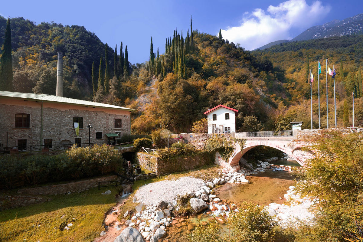
The oldest part of this paper mill dates back to the XV Century, it was then enlarged at the end of the XIX Century.
The paper mill ended its activity in 1962 and it’s now the seat of the Paper Museum since 2007.'
});
t.setStyle(
new ol.style.Style({
image: new ol.style.Circle({
fill: new ol.style.Fill({
color: 'red'
}),
radius: 8,
stroke: new ol.style.Stroke({
color: '#000000',
width: 1,
}),
}),
}),
);
iconList.push(t);
style['683'] = {
'Point': new ol.style.Style({
image: new ol.style.Circle({
fill: new ol.style.Fill({
color: 'rgba(255,255,0,0.6)',
}),
radius: 10,
stroke: new ol.style.Stroke({
color: '#ff0',
width: 1,
}),
}),
}),
'LineString': new ol.style.Style({
stroke: new ol.style.Stroke({
color: 'red',
width: 3,
}),
}),
'MultiLineString': new ol.style.Style({
stroke: new ol.style.Stroke({
color: 'red',
width: 3,
}),
}),
};
// GPX start
var t = new ol.Feature({
geometry: new ol.geom.Point(ol.proj.fromLonLat([10.605365, 45.652391])),
name: 'Maina Superiore',
description: '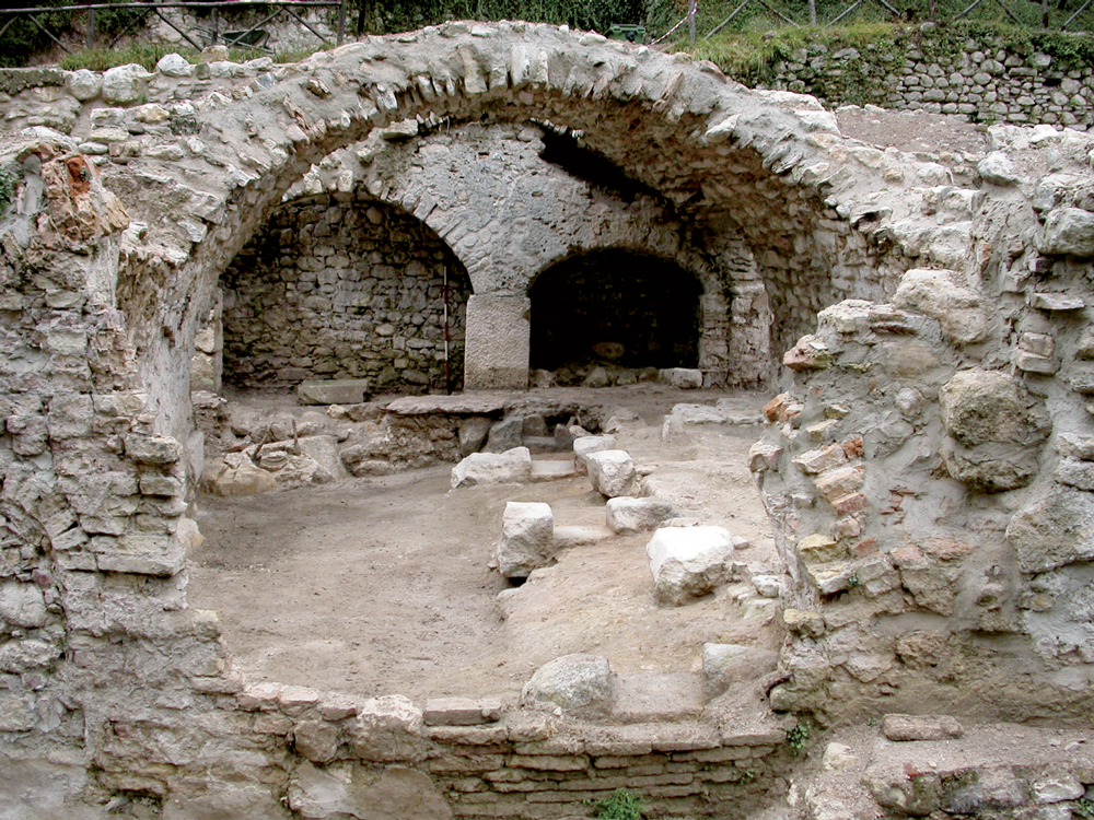
At the end of the XIX Century Maina Superiore was the main productive centre of this area and it represented the heart of a city made of factories, warehouse, channels, houses, gardens and tracks that filled the narrow valley floor. Here is the villa belonged to the Maffizzolis, leading personalities of the industrial development of the valley, and the ruins of their papermill. At the beginning of the XX Century the Maffizzolis abandoned this factory and moved the paper mill by the lake'
});
t.setStyle(
new ol.style.Style({
image: new ol.style.Circle({
fill: new ol.style.Fill({
color: 'red'
}),
radius: 8,
stroke: new ol.style.Stroke({
color: '#000000',
width: 1,
}),
}),
}),
);
iconList.push(t);
style['686'] = {
'Point': new ol.style.Style({
image: new ol.style.Circle({
fill: new ol.style.Fill({
color: 'rgba(255,255,0,0.6)',
}),
radius: 10,
stroke: new ol.style.Stroke({
color: '#ff0',
width: 1,
}),
}),
}),
'LineString': new ol.style.Style({
stroke: new ol.style.Stroke({
color: 'red',
width: 3,
}),
}),
'MultiLineString': new ol.style.Style({
stroke: new ol.style.Stroke({
color: 'red',
width: 3,
}),
}),
};
// GPX start
var t = new ol.Feature({
geometry: new ol.geom.Point(ol.proj.fromLonLat([10.606969, 45.653928])),
name: 'Vago [Vagh/Vach]',
description: '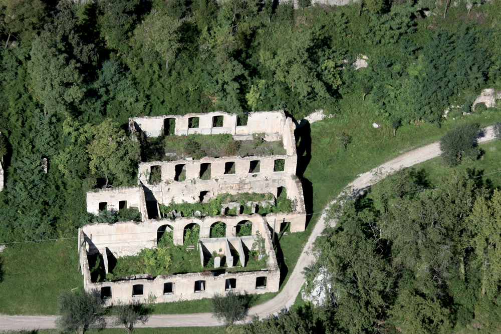
This part of the valley may takes its name from the dialect word vach, that refers to the wet and fresh climate that helped the cultivation of olive trees and grapevines. The first building that we find, with its typical industrial features, dates back to the XIX Century and it still preserves the big tiled tanks of the dutch machine and other concrete tanks that recall the deposit of chimicals used to bleach the pulp. Another building upstream, covered by vegetation, represents the eldest part of the productive complex of Vago.
'
});
t.setStyle(
new ol.style.Style({
image: new ol.style.Circle({
fill: new ol.style.Fill({
color: 'red'
}),
radius: 8,
stroke: new ol.style.Stroke({
color: '#000000',
width: 1,
}),
}),
}),
);
iconList.push(t);
style['687'] = {
'Point': new ol.style.Style({
image: new ol.style.Circle({
fill: new ol.style.Fill({
color: 'rgba(255,255,0,0.6)',
}),
radius: 10,
stroke: new ol.style.Stroke({
color: '#ff0',
width: 1,
}),
}),
}),
'LineString': new ol.style.Style({
stroke: new ol.style.Stroke({
color: 'red',
width: 3,
}),
}),
'MultiLineString': new ol.style.Style({
stroke: new ol.style.Stroke({
color: 'red',
width: 3,
}),
}),
};
// GPX start
var t = new ol.Feature({
geometry: new ol.geom.Point(ol.proj.fromLonLat([10.606623517149, 45.652427455979])),
name: 'Vancinelle',
description: 'Alongside the left bank of the river, the road took to a big building in Vancinelle, also known as Magazzino (warehouse) due to its use, built between 1852 and 1898, opposite to Maina Superiore, to which it was connceted by a bridge. The name of this locality may derives from the vernacular version of the name Avanzini (Vansinèl) who were famous papermills owner.'
});
t.setStyle(
new ol.style.Style({
image: new ol.style.Circle({
fill: new ol.style.Fill({
color: 'red'
}),
radius: 8,
stroke: new ol.style.Stroke({
color: '#000000',
width: 1,
}),
}),
}),
);
iconList.push(t);
var iconLayer = new ol.layer.Vector({
source: new ol.source.Vector({
features: iconList,
}),
});
vectorList_a.push(iconLayer);
var vectorList_27 = [];
var iconList = [];
style['771'] = {
'Point': new ol.style.Style({
image: new ol.style.Circle({
fill: new ol.style.Fill({
color: 'rgba(255,255,0,0.6)',
}),
radius: 10,
stroke: new ol.style.Stroke({
color: '#ff0',
width: 1,
}),
}),
}),
'LineString': new ol.style.Style({
stroke: new ol.style.Stroke({
color: '#e7ceb0',
width: 3,
}),
}),
'MultiLineString': new ol.style.Style({
stroke: new ol.style.Stroke({
color: '#e7ceb0',
width: 3,
}),
}),
};
// GPX start
var t = new ol.Feature({
geometry: new ol.geom.Point(ol.proj.fromLonLat([10.605244, 45.652062])),
name: 'Maffizzoli Palace',
description: '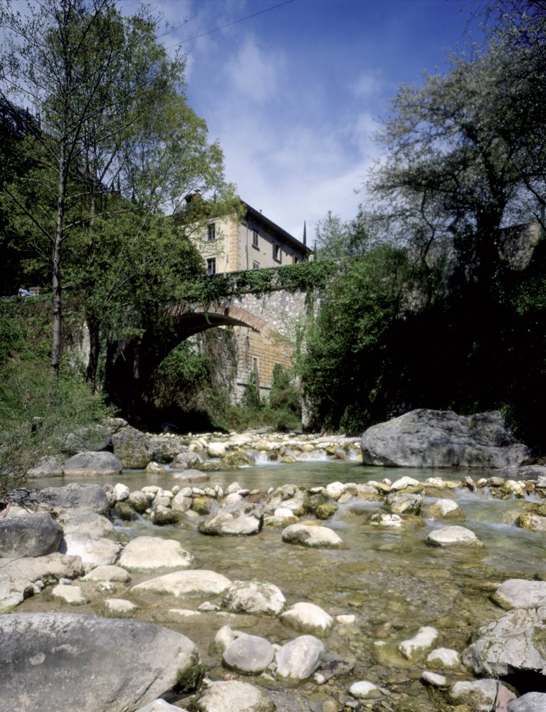
Property of the Maffizzoli family, famous paper makers. It was built on the side of the river at the entrance of Maina Superiore, that was the main paper production centre at the end of the 19th Century'
});
t.setStyle(
new ol.style.Style({
image: new ol.style.Circle({
fill: new ol.style.Fill({
color: '#e7ceb0'
}),
radius: 8,
stroke: new ol.style.Stroke({
color: '#000000',
width: 1,
}),
}),
}),
);
iconList.push(t);
var iconLayer = new ol.layer.Vector({
source: new ol.source.Vector({
features: iconList,
}),
});
vectorList_27.push(iconLayer);
var vectorList_24 = [];
var iconList = [];
style['725'] = {
'Point': new ol.style.Style({
image: new ol.style.Circle({
fill: new ol.style.Fill({
color: 'rgba(255,255,0,0.6)',
}),
radius: 10,
stroke: new ol.style.Stroke({
color: '#ff0',
width: 1,
}),
}),
}),
'LineString': new ol.style.Style({
stroke: new ol.style.Stroke({
color: '#be6acd',
width: 3,
}),
}),
'MultiLineString': new ol.style.Style({
stroke: new ol.style.Stroke({
color: '#be6acd',
width: 3,
}),
}),
};
// GPX start
var t = new ol.Feature({
geometry: new ol.geom.Point(ol.proj.fromLonLat([10.609422185742, 45.657457385446])),
name: 'St. Filippo and St. Giacomo\'s Church',
description: '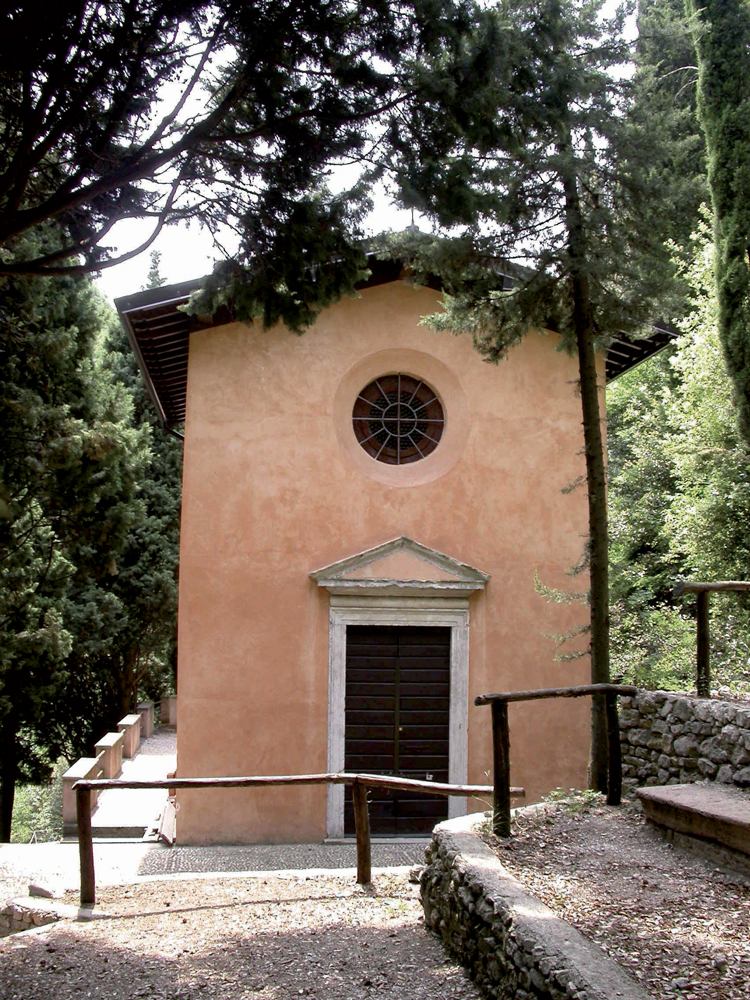
Small chapel realised during the 16th Century by the Tamagnini family. Dedicated to Filippo and Giacomo, protectors of paper makers.
Small and plain structure with beautiful stucco decorations made by Davide Rieti, famous sculptor who worked for the Dome in Salò and fort the Inviolata\'s Curch in Riva del Garda.
Abandoned over a long time, the church has been taken to its original beauty thanks to recent restoration works.
WARNING This part of the valley is temporarily closed
'
});
t.setStyle(
new ol.style.Style({
image: new ol.style.Circle({
fill: new ol.style.Fill({
color: '#be6acd'
}),
radius: 8,
stroke: new ol.style.Stroke({
color: '#000000',
width: 1,
}),
}),
}),
);
iconList.push(t);
var iconLayer = new ol.layer.Vector({
source: new ol.source.Vector({
features: iconList,
}),
});
vectorList_24.push(iconLayer);
var vectorList_26 = [];
var iconList = [];
style['707'] = {
'Point': new ol.style.Style({
image: new ol.style.Circle({
fill: new ol.style.Fill({
color: 'rgba(255,255,0,0.6)',
}),
radius: 10,
stroke: new ol.style.Stroke({
color: '#ff0',
width: 1,
}),
}),
}),
'LineString': new ol.style.Style({
stroke: new ol.style.Stroke({
color: '#3aa25f',
width: 3,
}),
}),
'MultiLineString': new ol.style.Style({
stroke: new ol.style.Stroke({
color: '#3aa25f',
width: 3,
}),
}),
};
// GPX start
var t = new ol.Feature({
geometry: new ol.geom.Point(ol.proj.fromLonLat([10.604170415888738, 45.64972537665636])),
name: 'The Paper Museum',
description: '
The paper production centre in Maina Inferiore is a fascinating productive complex transformed in museum. The museum recalls the different phases of paper production from the Middle age to the 20th Century, through an evocative path from the 16th Century nucleus of the mill, where visitors find reproductions of machinery and instruments typical of paper production from 15th to 18th Century to the upper rooms dedicated to the evolution of paper production during the early phases of the Industrial Revolution. In exhibition there are also some findings from the archaeological excavations carried out in the Paper Mill Valley, some watermarks produced between the 16th and 18th Century, and a collection of books printed by the Paganinis, illustrious publishers who owned a print shop in Toscolano and Venice during the first half of the 16th Century. Besides guided tours and didactic workshops about the history of paper, The Centre organises cultural events and exhibitions.
Info
www.valledellecartiere.it '
});
t.setStyle(
new ol.style.Style({
image: new ol.style.Circle({
fill: new ol.style.Fill({
color: '#3aa25f'
}),
radius: 8,
stroke: new ol.style.Stroke({
color: '#000000',
width: 1,
}),
}),
}),
);
iconList.push(t);
var iconLayer = new ol.layer.Vector({
source: new ol.source.Vector({
features: iconList,
}),
});
vectorList_26.push(iconLayer);
// PUNTI end ************************************************************************************
var view = new ol.View({
center: ol.proj.transform([10.600677, 45.648558], 'EPSG:4326', 'EPSG:3857'),
//maxZoom: 18,
zoom: 14
})
var map = new ol.Map({
//controls: ol.control.defaults().extend([new ol.control.FullScreen()]),
target: 'map',
overlays: [overlay],
layers: [
// LAYOUT DELLA CARTINA
new ol.layer.Group({
title: 'Show', // A layer must have a title to appear in the layerswitcher
layers: [
new ol.layer.Group({
title: 'Terrain', // A layer must have a title to appear in the layerswitcher
type: 'base', // Setting the layers type to 'base' results in it having a radio button and only one base layer being visibile at a time
combine: true, // Setting combine to true causes sub-layers to be hidden in the layerswitcher, only the parent is shown
visible: false,
layers: [
new ol.layer.Tile({
source: new ol.source.Stamen({
layer: 'terrain'
})
})
]
}),
new ol.layer.Tile({
title: 'Elevation contour lines',
type: 'base',
source: new ol.source.XYZ({
attributions: 'Tiles © ArcGIS',
url: 'https://server.arcgisonline.com/ArcGIS/rest/services/World_Topo_Map/MapServer/tile/{z}/{y}/{x}',
}),
}),
new ol.layer.Tile({
title: 'Satellite',
type: 'base',
source: new ol.source.XYZ({
attributions: 'Tiles © Esri — Source: Esri, i-cubed, USDA, USGS, AEX, GeoEye, Getmapping, Aerogrid, IGN, IGP, UPR-EGP, and the GIS User Community',
url: 'https://server.arcgisonline.com/ArcGIS/rest/services/World_Imagery/MapServer/tile/{z}/{y}/{x}.jpg',
maxZoom: 19,
}),
}),
new ol.layer.Tile({
title: 'Map', // A layer must have a title to appear in the layerswitcher
type: 'base', // Again set this layer as a base layer
visible: true,
source: new ol.source.OSM()
}),
]
}),
new ol.layer.Group({
title: 'Papermill Valley - Gaino',
fold: 'open', // Adding a 'fold' property set to either 'open' or 'close' makes the group layer collapsible
layers: [
new ol.layer.Group({
title: '•
GPS TRACK',
layers: vectorList_38
}),
new ol.layer.Group({
title: '•
Altro',
layers: vectorList_a
}),
new ol.layer.Group({
title: '•
VILLAS AND PALACES',
layers: vectorList_27
}),
new ol.layer.Group({
title: '•
CHURCHES',
layers: vectorList_24
}),
new ol.layer.Group({
title: '•
MUSEUMS AND PARKS',
layers: vectorList_26
}),
]
}),
],
view: view,
});
// GEOLOCALIZZAZIONE start ************************************************************************************
var geolocation = new ol.Geolocation({
// enableHighAccuracy must be set to true to have the heading value.
trackingOptions: {
enableHighAccuracy: true,
},
projection: view.getProjection(),
});
function el(id) {
return document.getElementById(id);
}
el('track').addEventListener('change', function () {
geolocation.setTracking(this.checked);
});
geolocation.on('change', function () {
el('accuracy').innerText = geolocation.getAccuracy() + ' [m]';
el('altitude').innerText = geolocation.getAltitude() + ' [m]';
el('altitudeAccuracy').innerText = geolocation.getAltitudeAccuracy() + ' [m]';
el('heading').innerText = geolocation.getHeading() + ' [rad]';
el('speed').innerText = geolocation.getSpeed() + ' [m/s]';
el('position').innerText = geolocation.getPosition();
});
// handle geolocation error.
geolocation.on('error', function (error) {
var info = document.getElementById('info-track');
info.innerHTML = error.message;
info.style.display = '';
});
var accuracyFeature = new ol.Feature();
geolocation.on('change:accuracyGeometry', function () {
accuracyFeature.setGeometry(geolocation.getAccuracyGeometry());
map.getView().animate({ center: geolocation.getPosition() }, { duration: 750 });
});
var positionFeature = new ol.Feature();
positionFeature.setStyle(
new ol.style.Style({
image: new ol.style.Circle({
radius: 6,
fill: new ol.style.Fill({
color: '#3399CC',
}),
stroke: new ol.style.Stroke({
color: '#fff',
width: 2,
}),
}),
})
);
// geolocation.on('change:position', function () {
geolocation.on('change', function () {
var coordinates = geolocation.getPosition();
positionFeature.setGeometry(coordinates ? new ol.geom.Point(coordinates) : null);
});
new ol.layer.Vector({
map: map,
source: new ol.source.Vector({
features: [accuracyFeature, positionFeature],
}),
});
// GEOLOCALIZZAZIONE end ************************************************************************************
// LINK To POINT start ************************************************************************************
// LINK To POINT end ************************************************************************************
// POPOUP start ************************************************************************************
var element = document.getElementById('popup');
var popup = new ol.Overlay({
element: element,
positioning: 'bottom-center',
stopEvent: false,
offset: [0, 0],
});
map.addOverlay(popup);
map.on('singleclick', function (evt) {
$(element).popover('dispose');
var feature = map.forEachFeatureAtPixel(evt.pixel, function (feature) {
return feature;
});
if (feature) {
var coordinate = evt.coordinate;
var hdms = ol.coordinate.toStringHDMS(ol.proj.toLonLat(coordinate));
content.innerHTML = '' + feature.get('name') + '
' + feature.get('description') + '
' + hdms + '';
overlay.setPosition(coordinate);
}
});
// POPOUP end ************************************************************************************
// Get out-of-the-map div element with the ID "layers" and renders layers to it.
// NOTE: If the layers are changed outside of the layer switcher then you
// will need to call ol.control.LayerSwitcher.renderPanel again to refesh
// the layer tree. Style the tree via CSS.
var sidebar = new ol.control.Sidebar({
element: 'sidebar',
position: 'left'
});
var toc = document.getElementById('layers');
ol.control.LayerSwitcher.renderPanel(map, toc, { reverse: true });
map.addControl(sidebar);
})();