(function () {
var container = document.getElementById('popup2');
var content = document.getElementById('popup-content');
var closer = document.getElementById('popup-closer');
var overlay = new ol.Overlay({
element: container,
autoPan: true,
autoPanAnimation: {
duration: 250,
},
});
closer.onclick = function () {
overlay.setPosition(undefined);
closer.blur();
return false;
};
// PUNTI start ************************************************************************************
var style = [];
var vectorList_a = [];
var iconList = [];
style['755'] = {
'LineString': new ol.style.Style({
stroke: new ol.style.Stroke({
color: 'red',
width: 3,
}),
}),
'MultiLineString': new ol.style.Style({
stroke: new ol.style.Stroke({
color: 'red',
width: 3,
}),
}),
};
// GPX start
var vectorgpx = new ol.layer.Vector({
name: 'Sentiero degli Orticelli',
description: ' ',
source: new ol.source.Vector({
url: ['/files/gpx/track_M.gpx'],
radius: 0,
format: new ol.format.GPX()
}),
style: function (feature) {
return style['755'][feature.getGeometry().getType()];
},
});
vectorList_a.push(vectorgpx);
var iconLayer = new ol.layer.Vector({
source: new ol.source.Vector({
features: iconList,
}),
});
vectorList_a.push(iconLayer);
var vectorList_38 = [];
var iconList = [];
style['663'] = {
'LineString': new ol.style.Style({
stroke: new ol.style.Stroke({
color: 'black',
width: 3,
}),
}),
'MultiLineString': new ol.style.Style({
stroke: new ol.style.Stroke({
color: 'black',
width: 3,
}),
}),
};
// GPX start
var vectorgpx = new ol.layer.Vector({
name: 'Sentiero degli Orticelli',
description: 'Si parcheggia sulla strada Statale 45 bis, alla Cappella dei Viandanti si sale a destra sopra la Statale per un sentiero panoramico fino a MESSAGA, lungo il percorso si può ammirare una tipica limonaia.
Poco dopo, si passa sotto un volto, si gira a destra e si scende verso la Cappella di Marsina.
Si gira a sinistra tra gli uliveti proseguendo per via Marsina fino al centro storico di Cecina.
Si prosegue sempre a sinistra per via Marsina e poi per via Cecina fino al parcheggio, si gira a sinistra per via Messaga fino al Palazzo Zuanelli (ammirare il portone) e la Chiesetta di S. Antonio2.
Si tiene la destra fino all’incrocio, dove si gira a sinistra per Vicolo Messaga, da notare la stele di Gabriele di Pietro3.
Si passa sotto un volto e dopo circa 80 mt all’incrocio, si gira a destra, e si ridiscende per la strada vicinale degli Orticelli fino alla Cappella dei Viandanti.
Lunghezza: 2,5 km
Dislivello: 120 m
Durata: 1:30 h
Partenza: Toscolano, via Statale
Arrivo: Messaga
Difficoltà: T - Turistico
',
source: new ol.source.Vector({
url: ['/files/gpx/orticelli.gpx'],
radius: 0,
format: new ol.format.GPX()
}),
style: function (feature) {
return style['663'][feature.getGeometry().getType()];
},
});
vectorList_38.push(vectorgpx);
var iconLayer = new ol.layer.Vector({
source: new ol.source.Vector({
features: iconList,
}),
});
vectorList_38.push(iconLayer);
var vectorList_24 = [];
var iconList = [];
style['712'] = {
'Point': new ol.style.Style({
image: new ol.style.Circle({
fill: new ol.style.Fill({
color: 'rgba(255,255,0,0.6)',
}),
radius: 10,
stroke: new ol.style.Stroke({
color: '#ff0',
width: 1,
}),
}),
}),
'LineString': new ol.style.Style({
stroke: new ol.style.Stroke({
color: '#be6acd',
width: 3,
}),
}),
'MultiLineString': new ol.style.Style({
stroke: new ol.style.Stroke({
color: '#be6acd',
width: 3,
}),
}),
};
// GPX start
var t = new ol.Feature({
geometry: new ol.geom.Point(ol.proj.fromLonLat([10.630855041267, 45.656695606253])),
name: 'Chiesa di San Nicola',
description: '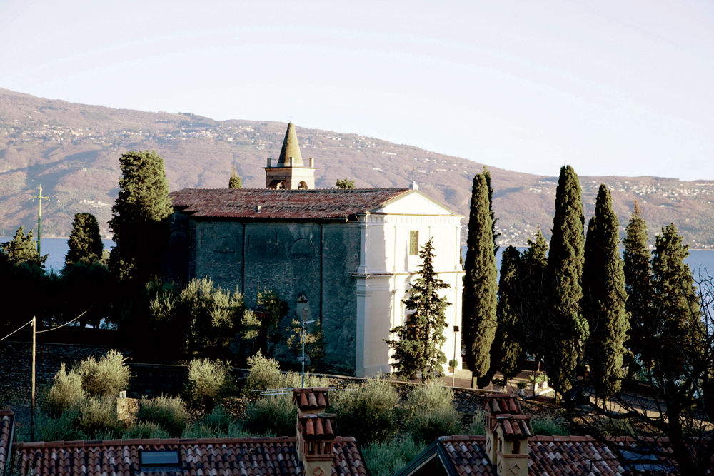
La parrocchiale si trova sopra un piccolo cocuzzolo all’estremità nord di Cecina. Di origini medievali, fu restaurata da Pasino Gozio dei Boselli nel XVI secolo. All’interno si conserva il ritratto di un giovane del casato Boselli, risalente al Cinquecento e attribuito a Girolamo Pilotti. La chiesa fu ampliata con l’aggiunta di due cappelle laterali davanti alle quali si trovano le tombe della nobile famiglia degli Zuanelli, decorate dagli stemmi gentilizi. Il più suntuoso è quello dedicato alla Madonna con il Bambino, che conserva un affresco quattrocentesco, incluso in una cornice barocca in stucco. Di fronte si trova l’altare dedicato a Sant’Alipio con San Domenico e Filippo Neri realizzato nel 1701, che custodisce un dipinto del pittore veneziano Andrea Celesti (1637-1712 ca). Dello stesso autore sono anche le pale degli altri due altari più vicini al presbiterio, raffiguranti la Lapidazione di Santo Stefano e la Madonna in gloria tra i Santi Giovanni Battista, Lucia e Rocco.'
});
t.setStyle(
new ol.style.Style({
image: new ol.style.Circle({
fill: new ol.style.Fill({
color: '#be6acd'
}),
radius: 8,
stroke: new ol.style.Stroke({
color: '#000000',
width: 1,
}),
}),
}),
);
iconList.push(t);
var iconLayer = new ol.layer.Vector({
source: new ol.source.Vector({
features: iconList,
}),
});
vectorList_24.push(iconLayer);
// PUNTI end ************************************************************************************
var view = new ol.View({
center: ol.proj.transform([10.600677, 45.648558], 'EPSG:4326', 'EPSG:3857'),
//maxZoom: 18,
zoom: 14
})
var map = new ol.Map({
//controls: ol.control.defaults().extend([new ol.control.FullScreen()]),
target: 'map',
overlays: [overlay],
layers: [
// LAYOUT DELLA CARTINA
new ol.layer.Group({
title: 'Visualizza', // A layer must have a title to appear in the layerswitcher
layers: [
new ol.layer.Group({
title: 'Terreno', // A layer must have a title to appear in the layerswitcher
type: 'base', // Setting the layers type to 'base' results in it having a radio button and only one base layer being visibile at a time
combine: true, // Setting combine to true causes sub-layers to be hidden in the layerswitcher, only the parent is shown
visible: false,
layers: [
new ol.layer.Tile({
source: new ol.source.Stamen({
layer: 'terrain'
})
})
]
}),
new ol.layer.Tile({
title: 'Curve di livello',
type: 'base',
source: new ol.source.XYZ({
attributions: 'Tiles © ArcGIS',
url: 'https://server.arcgisonline.com/ArcGIS/rest/services/World_Topo_Map/MapServer/tile/{z}/{y}/{x}',
}),
}),
new ol.layer.Tile({
title: 'Satellite',
type: 'base',
source: new ol.source.XYZ({
attributions: 'Tiles © Esri — Source: Esri, i-cubed, USDA, USGS, AEX, GeoEye, Getmapping, Aerogrid, IGN, IGP, UPR-EGP, and the GIS User Community',
url: 'https://server.arcgisonline.com/ArcGIS/rest/services/World_Imagery/MapServer/tile/{z}/{y}/{x}.jpg',
maxZoom: 19,
}),
}),
new ol.layer.Tile({
title: 'Mappa', // A layer must have a title to appear in the layerswitcher
type: 'base', // Again set this layer as a base layer
visible: true,
source: new ol.source.OSM()
}),
]
}),
new ol.layer.Group({
title: 'Sentiero degli Orticelli',
fold: 'open', // Adding a 'fold' property set to either 'open' or 'close' makes the group layer collapsible
layers: [
new ol.layer.Group({
title: '•
Altro',
layers: vectorList_a
}),
new ol.layer.Group({
title: '•
TRACCIA GPS',
layers: vectorList_38
}),
new ol.layer.Group({
title: '•
CHIESE',
layers: vectorList_24
}),
]
}),
],
view: view,
});
// GEOLOCALIZZAZIONE start ************************************************************************************
var geolocation = new ol.Geolocation({
// enableHighAccuracy must be set to true to have the heading value.
trackingOptions: {
enableHighAccuracy: true,
},
projection: view.getProjection(),
});
function el(id) {
return document.getElementById(id);
}
el('track').addEventListener('change', function () {
geolocation.setTracking(this.checked);
});
geolocation.on('change', function () {
el('accuracy').innerText = geolocation.getAccuracy() + ' [m]';
el('altitude').innerText = geolocation.getAltitude() + ' [m]';
el('altitudeAccuracy').innerText = geolocation.getAltitudeAccuracy() + ' [m]';
el('heading').innerText = geolocation.getHeading() + ' [rad]';
el('speed').innerText = geolocation.getSpeed() + ' [m/s]';
el('position').innerText = geolocation.getPosition();
});
// handle geolocation error.
geolocation.on('error', function (error) {
var info = document.getElementById('info-track');
info.innerHTML = error.message;
info.style.display = '';
});
var accuracyFeature = new ol.Feature();
geolocation.on('change:accuracyGeometry', function () {
accuracyFeature.setGeometry(geolocation.getAccuracyGeometry());
map.getView().animate({ center: geolocation.getPosition() }, { duration: 750 });
});
var positionFeature = new ol.Feature();
positionFeature.setStyle(
new ol.style.Style({
image: new ol.style.Circle({
radius: 6,
fill: new ol.style.Fill({
color: '#3399CC',
}),
stroke: new ol.style.Stroke({
color: '#fff',
width: 2,
}),
}),
})
);
// geolocation.on('change:position', function () {
geolocation.on('change', function () {
var coordinates = geolocation.getPosition();
positionFeature.setGeometry(coordinates ? new ol.geom.Point(coordinates) : null);
});
new ol.layer.Vector({
map: map,
source: new ol.source.Vector({
features: [accuracyFeature, positionFeature],
}),
});
// GEOLOCALIZZAZIONE end ************************************************************************************
// LINK To POINT start ************************************************************************************
// LINK To POINT end ************************************************************************************
// POPOUP start ************************************************************************************
var element = document.getElementById('popup');
var popup = new ol.Overlay({
element: element,
positioning: 'bottom-center',
stopEvent: false,
offset: [0, 0],
});
map.addOverlay(popup);
map.on('singleclick', function (evt) {
$(element).popover('dispose');
var feature = map.forEachFeatureAtPixel(evt.pixel, function (feature) {
return feature;
});
if (feature) {
var coordinate = evt.coordinate;
var hdms = ol.coordinate.toStringHDMS(ol.proj.toLonLat(coordinate));
content.innerHTML = '' + feature.get('name') + '
' + feature.get('description') + '
' + hdms + '';
overlay.setPosition(coordinate);
}
});
// POPOUP end ************************************************************************************
// Get out-of-the-map div element with the ID "layers" and renders layers to it.
// NOTE: If the layers are changed outside of the layer switcher then you
// will need to call ol.control.LayerSwitcher.renderPanel again to refesh
// the layer tree. Style the tree via CSS.
var sidebar = new ol.control.Sidebar({
element: 'sidebar',
position: 'left'
});
var toc = document.getElementById('layers');
ol.control.LayerSwitcher.renderPanel(map, toc, { reverse: true });
map.addControl(sidebar);
})();