(function () {
var container = document.getElementById('popup2');
var content = document.getElementById('popup-content');
var closer = document.getElementById('popup-closer');
var overlay = new ol.Overlay({
element: container,
autoPan: true,
autoPanAnimation: {
duration: 250,
},
});
closer.onclick = function () {
overlay.setPosition(undefined);
closer.blur();
return false;
};
// PUNTI start ************************************************************************************
var style = [];
var vectorList_a = [];
var iconList = [];
style['688'] = {
'LineString': new ol.style.Style({
stroke: new ol.style.Stroke({
color: 'red',
width: 3,
}),
}),
'MultiLineString': new ol.style.Style({
stroke: new ol.style.Stroke({
color: 'red',
width: 3,
}),
}),
};
// GPX start
var vectorgpx = new ol.layer.Vector({
name: 'Campei de Sima',
description: '
',
source: new ol.source.Vector({
url: ['/files/gpx/campei.gpx'],
radius: 0,
format: new ol.format.GPX()
}),
style: function (feature) {
return style['688'][feature.getGeometry().getType()];
},
});
vectorList_a.push(vectorgpx);
var iconLayer = new ol.layer.Vector({
source: new ol.source.Vector({
features: iconList,
}),
});
vectorList_a.push(iconLayer);
var vectorList_19 = [];
var iconList = [];
style['669'] = {
'Point': new ol.style.Style({
image: new ol.style.Circle({
fill: new ol.style.Fill({
color: 'rgba(255,255,0,0.6)',
}),
radius: 10,
stroke: new ol.style.Stroke({
color: '#ff0',
width: 1,
}),
}),
}),
'LineString': new ol.style.Style({
stroke: new ol.style.Stroke({
color: '#159181',
width: 3,
}),
}),
'MultiLineString': new ol.style.Style({
stroke: new ol.style.Stroke({
color: '#159181',
width: 3,
}),
}),
};
// GPX start
var t = new ol.Feature({
geometry: new ol.geom.Point(ol.proj.fromLonLat([10.560180804632, 45.697801215542])),
name: 'Campèi de Sima',
description: '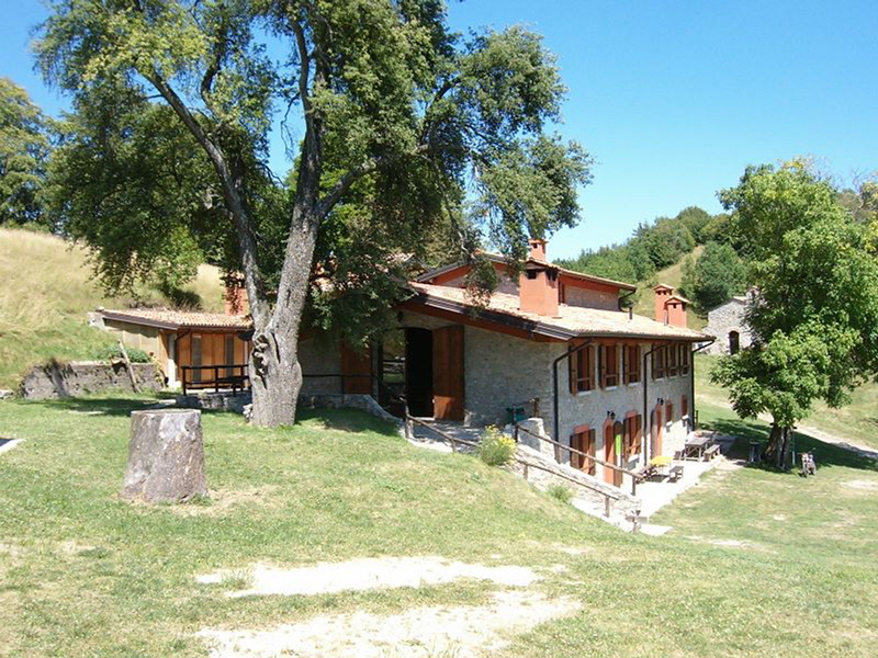
Il Rifugio Sezionale si trova a Campiglio di Cima (Campèi de Sìma), località del Comune di Toscolano Maderno, all’interno del Parco Naturalistico Alto Garda Bresciano, ad un\'altezza di 1.017 metri. Più che di un rifugio si tratta di un vero e proprio “borgo alpino”, composto da tre fabbricati e da una chiesetta intitolata alla Madonna della Neve. La ristrutturazione terminata nel 2000, frutto della sinergia tra ERSAF (proprietario dei fabbricati) e A.N.A., ha permesso nel giro di cinque anni di rendere fruibile il complesso delle malghe di Campiglio di Cima.'
});
t.setStyle(
new ol.style.Style({
image: new ol.style.Circle({
fill: new ol.style.Fill({
color: '#159181'
}),
radius: 8,
stroke: new ol.style.Stroke({
color: '#000000',
width: 1,
}),
}),
}),
);
iconList.push(t);
var iconLayer = new ol.layer.Vector({
source: new ol.source.Vector({
features: iconList,
}),
});
vectorList_19.push(iconLayer);
var vectorList_24 = [];
var iconList = [];
style['736'] = {
'Point': new ol.style.Style({
image: new ol.style.Circle({
fill: new ol.style.Fill({
color: 'rgba(255,255,0,0.6)',
}),
radius: 10,
stroke: new ol.style.Stroke({
color: '#ff0',
width: 1,
}),
}),
}),
'LineString': new ol.style.Style({
stroke: new ol.style.Stroke({
color: '#be6acd',
width: 3,
}),
}),
'MultiLineString': new ol.style.Style({
stroke: new ol.style.Stroke({
color: '#be6acd',
width: 3,
}),
}),
};
// GPX start
var t = new ol.Feature({
geometry: new ol.geom.Point(ol.proj.fromLonLat([10.560028591989914, 45.69792022216966])),
name: 'Santa Maria della Neve',
description: 'In località Campiglio di Cima a 1025 metri d’altitudine sorge la piccola chiesa dedicata a Santa Maria della Neve, che risale al 1602. Fu costruita insieme alla malga e ad alcuni edifici dalla famiglia Andreoli, mandriani della Valvestino che abitavano in questa località. Nel XVII secolo fu abbellita per volontà della pia signora Stefania Zambelli di Gaino, che ogni mese vi si recava qualunque fossero le condizioni climatiche. Il complesso, di proprietà dell’Azienda delle Foreste, è stato interamente restaurato dagli Alpini, che lo gestiscono come rifugio. '
});
t.setStyle(
new ol.style.Style({
image: new ol.style.Circle({
fill: new ol.style.Fill({
color: '#be6acd'
}),
radius: 8,
stroke: new ol.style.Stroke({
color: '#000000',
width: 1,
}),
}),
}),
);
iconList.push(t);
var iconLayer = new ol.layer.Vector({
source: new ol.source.Vector({
features: iconList,
}),
});
vectorList_24.push(iconLayer);
// PUNTI end ************************************************************************************
var view = new ol.View({
center: ol.proj.transform([10.600677, 45.648558], 'EPSG:4326', 'EPSG:3857'),
//maxZoom: 18,
zoom: 14
})
var map = new ol.Map({
//controls: ol.control.defaults().extend([new ol.control.FullScreen()]),
target: 'map',
overlays: [overlay],
layers: [
// LAYOUT DELLA CARTINA
new ol.layer.Group({
title: 'Visualizza', // A layer must have a title to appear in the layerswitcher
layers: [
new ol.layer.Group({
title: 'Terreno', // A layer must have a title to appear in the layerswitcher
type: 'base', // Setting the layers type to 'base' results in it having a radio button and only one base layer being visibile at a time
combine: true, // Setting combine to true causes sub-layers to be hidden in the layerswitcher, only the parent is shown
visible: false,
layers: [
new ol.layer.Tile({
source: new ol.source.Stamen({
layer: 'terrain'
})
})
]
}),
new ol.layer.Tile({
title: 'Curve di livello',
type: 'base',
source: new ol.source.XYZ({
attributions: 'Tiles © ArcGIS',
url: 'https://server.arcgisonline.com/ArcGIS/rest/services/World_Topo_Map/MapServer/tile/{z}/{y}/{x}',
}),
}),
new ol.layer.Tile({
title: 'Satellite',
type: 'base',
source: new ol.source.XYZ({
attributions: 'Tiles © Esri — Source: Esri, i-cubed, USDA, USGS, AEX, GeoEye, Getmapping, Aerogrid, IGN, IGP, UPR-EGP, and the GIS User Community',
url: 'https://server.arcgisonline.com/ArcGIS/rest/services/World_Imagery/MapServer/tile/{z}/{y}/{x}.jpg',
maxZoom: 19,
}),
}),
new ol.layer.Tile({
title: 'Mappa', // A layer must have a title to appear in the layerswitcher
type: 'base', // Again set this layer as a base layer
visible: true,
source: new ol.source.OSM()
}),
]
}),
new ol.layer.Group({
title: 'Campei de Sima',
fold: 'open', // Adding a 'fold' property set to either 'open' or 'close' makes the group layer collapsible
layers: [
new ol.layer.Group({
title: '•
Altro',
layers: vectorList_a
}),
new ol.layer.Group({
title: '•
RIFUGIO',
layers: vectorList_19
}),
new ol.layer.Group({
title: '•
CHIESE',
layers: vectorList_24
}),
]
}),
],
view: view,
});
// GEOLOCALIZZAZIONE start ************************************************************************************
var geolocation = new ol.Geolocation({
// enableHighAccuracy must be set to true to have the heading value.
trackingOptions: {
enableHighAccuracy: true,
},
projection: view.getProjection(),
});
function el(id) {
return document.getElementById(id);
}
el('track').addEventListener('change', function () {
geolocation.setTracking(this.checked);
});
geolocation.on('change', function () {
el('accuracy').innerText = geolocation.getAccuracy() + ' [m]';
el('altitude').innerText = geolocation.getAltitude() + ' [m]';
el('altitudeAccuracy').innerText = geolocation.getAltitudeAccuracy() + ' [m]';
el('heading').innerText = geolocation.getHeading() + ' [rad]';
el('speed').innerText = geolocation.getSpeed() + ' [m/s]';
el('position').innerText = geolocation.getPosition();
});
// handle geolocation error.
geolocation.on('error', function (error) {
var info = document.getElementById('info-track');
info.innerHTML = error.message;
info.style.display = '';
});
var accuracyFeature = new ol.Feature();
geolocation.on('change:accuracyGeometry', function () {
accuracyFeature.setGeometry(geolocation.getAccuracyGeometry());
map.getView().animate({ center: geolocation.getPosition() }, { duration: 750 });
});
var positionFeature = new ol.Feature();
positionFeature.setStyle(
new ol.style.Style({
image: new ol.style.Circle({
radius: 6,
fill: new ol.style.Fill({
color: '#3399CC',
}),
stroke: new ol.style.Stroke({
color: '#fff',
width: 2,
}),
}),
})
);
// geolocation.on('change:position', function () {
geolocation.on('change', function () {
var coordinates = geolocation.getPosition();
positionFeature.setGeometry(coordinates ? new ol.geom.Point(coordinates) : null);
});
new ol.layer.Vector({
map: map,
source: new ol.source.Vector({
features: [accuracyFeature, positionFeature],
}),
});
// GEOLOCALIZZAZIONE end ************************************************************************************
// LINK To POINT start ************************************************************************************
// LINK To POINT end ************************************************************************************
// POPOUP start ************************************************************************************
var element = document.getElementById('popup');
var popup = new ol.Overlay({
element: element,
positioning: 'bottom-center',
stopEvent: false,
offset: [0, 0],
});
map.addOverlay(popup);
map.on('singleclick', function (evt) {
$(element).popover('dispose');
var feature = map.forEachFeatureAtPixel(evt.pixel, function (feature) {
return feature;
});
if (feature) {
var coordinate = evt.coordinate;
var hdms = ol.coordinate.toStringHDMS(ol.proj.toLonLat(coordinate));
content.innerHTML = '' + feature.get('name') + '
' + feature.get('description') + '
' + hdms + '';
overlay.setPosition(coordinate);
}
});
// POPOUP end ************************************************************************************
// Get out-of-the-map div element with the ID "layers" and renders layers to it.
// NOTE: If the layers are changed outside of the layer switcher then you
// will need to call ol.control.LayerSwitcher.renderPanel again to refesh
// the layer tree. Style the tree via CSS.
var sidebar = new ol.control.Sidebar({
element: 'sidebar',
position: 'left'
});
var toc = document.getElementById('layers');
ol.control.LayerSwitcher.renderPanel(map, toc, { reverse: true });
map.addControl(sidebar);
})();